Friday, March 9, 2012

Sao Gabriel da Cachoiera, Brazil


 Dear friends and family,

We last wrote you from Puerto Ayacucho, where we obtained the permits necessary to continue up the Orinoco River into Brazil. The grand finale was a boat search by the Department of Military Intelligence that took seven men three hours. They even checked our camera and computer storage devices, but still couldn’t find any incriminating material. During the process a couple of them sidled up to Steve and whispered that they want to go to America. Like this was the Cold War and they wanted to defect to the West!


On February 17, 2012 Virgilio, our hard-working friend and tourist agent, loaded Thurston onto a trailer and towed us with his old Toyota pickup over a paved road to Samariapo, a landing upstream of the rapids. About a hundred boats were there, mostly bongos (long, slender, steel canoes with outboard motors), transporting people and supplies on the upper river.


As we continued upstream Venezuela was still on our left, Colombia on our right. If the current was too strong in one channel we found another. There were now hills on both sides of the river and the forest was denser. At the town of San Fernando de Atabapo the river turned away from the border; both banks were now Venezuelan soil. It was a relief to get away from that source of tension. The armed forces of the two countries are hostile toward each other, and Colombian guerrilleros still operate along the border on a reduced scale.

After Atabapo we followed the river southeast. It shrunk as we passed tributary mouths but it never became less than a quarter mile wide. Running our motor at 2/3 throttle we circled around sandbars and globular granite rocks. Sometimes we hugged the bank, other times we went down the center. At times we walked the boat when it became too shallow, the river being very low at this time of year. Our 100 liters of fuel resided in 20-liter containers lashed to either side of the cabin. We gave away the containers as they became empty. We used up the last of our bread and fruit and dug into our canned food. We passed a couple indigenous communities per day, typically ten or so neat mud-and-wattle houses and an open assembly hall around a grassy common. The foreign missionaries who organized these evangelist communities were expelled about ten years ago, though Venezuelan missionaries still visit. In some villages they spoke Wotuja, in others they spoke Kurripako. The people mostly ate fish, yucca, and plantains. They were friendly and quiet.

In Venezuela gasoline is virtually free. To keep the Venezuelans from reselling their gas to Colombians across the river the government requires all boats to stop at a string of Guardia Nacional checkpoints and get their papers stamped. We stopped at six such posts. Some coincided with indigenous communities, some were just a building in the wilderness. The young soldiers were bored and listless.

All day we droned upriver with our earplugs in, probing with our boat hook to check water depth. We now passed among tepuys: huge mesas such as Sir Arthur Conan Doyle popularized in his book The Lost World. Scarlet macaws flew overhead in twos and threes cawing like crows. Large black-and-yellow birds tended their young in teardrop-shaped nests that hung from the trees. Rust-breasted kingfishers flew from one overlooking branch to another. Then Jackpot! Ginny spotted an animal swimming across the river. Steve motored to it. A giant ant-eater! It reached the far bank and pulled itself out of the water. We gasped as it revealed its great length, six feet counting its big bushy tail and long, droopy snout! It tried to climb the bank but it was too steep, so it followed the waterline until it disappeared in some vegetation. Someone told us each anteater paw consists of a single gigantic claw! Another time we surprised a swimming cougar! When it saw us it turned around and swam with surprising speed to the shore it had started from, where it stared at us until we were past.

On our seventh day out of Puerto Ayacucho we reached the geographic phenomenon we had long yearned for: the Brazo Casiquiare distributary! There was no signpost, no break in the uninterrupted jungle. Maybe one twentieth of the Orinoco simply split off and disappeared southward toward the Amazon. Both branches would eventually reach the Atlantic but via mouths that are thousands of miles apart! We had reached the hump. Until now any mechanical malfunction could require us to give up and follow the Orinoco back downstream. Now we could row with the current. Until our gas should run out we fell into a new pattern of rowing three hours per day and motoring for six.

Local tributaries quickly added their translucent black water to the turbid brown Orinoco water that the Casiquiare had started with. Initially only fifty yards wide, it grew and became blacker and clearer. This was the most isolated part of our passage. The communities which our maps showed along the Brazo Casiquiare didn’t exist. For four days, averaging seventy kilometers per day, we saw no sign of man on shore and few boats on the water. When not steering the boat or admiring the scenery Steve practiced the guitar or sewed, Ginny read or washed clothes.


On the Orinoco we had slept moored in front of native settlements or well-hidden in tributary creeks, for security and privacy. Here there was no need to hide. We camped at scenic confluences or next to dramatic rocks. In the twilight bats fluttered about like large moths. It was frustrating to hear strange night calls and have no idea what was making them: birds, bats, insects, monkeys? One morning a coral snake slowly swam along the swampy shore we were tied to. “Red next to yellow you’re a dead fellow, red next to black you’re alright Jack,” recited Ginny. “He’s got red next to yellow so he’s poisonous!” By day a new species of biting insect plagued us, between a mosquito and a no-see-um in size, whose itchy bites have a red dot in the center. We battled one ant invasion after another and learned to tie up to trees that stand in the water so they can’t come aboard.

On the fourth day we arrived at a Yanomami settlement. These people are usually photographed wearing loincloths and with narrow sticks inserted horizontally through the skin of their faces. Our Yanomamis, like the other indigenous people we had met, wore factory-made shorts and skirts. We landed where a crowd of children were playing in the river. Ginny swam with them while a tiny man showed Steve around the thatch houses. On the packed earth under an open shelter a young man was hypnotically chanting and dancing. He wore paint on his face and arms and had feather arrays projecting from either side of his head. Steve’s Spanish-speaking guide said he was under the influence of a drug, a powder that one person blows into the nostrils of another. He said that the song was traditional and is for communicating with nature spirits.

Tribal villages proliferated as we neared the mouth of the Brazo Casiquiare. On February 29 the latter joined the Rio Negro. Each was a half kilometer wide, of the same translucent black. We now had Colombia on the right bank again. On the left bank was San Carlos del Rio Negro, administrative center for this remote part of Venezuela.

San Carlos didn’t have internet or a restaurant, but it had a Guardia Nacional post and a naval base. The naval comandante, a fastidious man with a golden retriever puppy, invited us into his office. He fondly reminisced about living in Alabama as a teenager while his father attended F-16 flight school. He showed us his cherished photos of Epcot Center and Disney World, but he also defended Chavez’s policies. We responded just enough to be polite. He complained that the U.S. won’t sell them spare parts for their Hercules air transporters, and that CNN distorts the news about Venezuela. He went on for hours in a curious balance of friendliness and tension. He seemed torn between Chavez’s xenophobic demagoguery and a repressed fear that Venezuela was becoming increasingly isolated. “We need a change!” he murmured. He also had nothing good to say about the Colombian navy, who had a base just across the river from his own. “They buzz by here and goose their engines just to provoke us!” he scowled.

On March 2, when our GPS indicated that we had left Venezuela, Ginny high-fived Steve. “Adios assholes!” she bellowed, referring not to the generous people but to the government. Their policies had complicated our lives in ways we have explained and in another matter which we can divulge now that we are out of the country. It pertains to their currency.

The bolivar is a controlled currency, meaning that the government sets its official value relative to other currencies. The value it sets is artificially high, so if a traveler exchanges his or her native currency for bolivares in a Venezuelan bank or ATM (which automatically converts the withdrawal to bolivares) his or her cost of living while in Venezuela will be about twice as high as the free market would dictate. We had gotten around this by:
1) estimating how many months we would be the country,
2) multiplying that by our past average of expenses per month,
3) building up a stash of US bills in that amount while in Colombia (we had to convert to pesos then back to dollars), and
4) exchanging our dollars for bolivares on the black market in Venezuela.

Carrying thousands of dollars in cash had added to our stress. So had the black market transactions. In some towns it was easy: you just ask around at stores. In other towns it was difficult to find a dealer. Then we ran out of dollars due to the fees levied upon us and the long waits for permits. We got around this once by a quick visit to a Colombian ATM and another time by using PayPal to transfer funds to the U.S. bank account of an affluent Venezuelan. Once the transfer cleared he gave us our bolivares at the good rate. We’d had to hide all this activity from scrutinizing officials as it is a crime punishable by huge fines and possible imprisonment.


All that behind us now, we hungrily opened our senses to this new country. Brazil was huge and flat, still totally forested but with isolated mountains here and there. We had entered a region still in its rainy season; showers were frequent, otherwise it was very hot. The banks were often inundated forests. There were palms with upward-radiating fronds and hardwoods with buttress roots. Some trees sported yellow or magenta flowers, others had large pendant pods. Giants with thick, straight trunks held spherical canopies above all the others. Vines smothered many trees. Curlicue rope vines dangled here and there, their tips often dragging in the river current. The people, mostly indigenous, drove dugout canoes sporting outboard motors with long propeller shafts projecting aft into the water. One had a radio playing. To Steve’s unaccustomed ear the music sounded like Cajun: rock-and-roll chord progressions at dance tempo with accordion and strings. The settlements had plank-built homes, old stucco churches, and stands of coconut and banana trees.

One campsite deserves special description. As the sun dropped low we descended a side-channel of the river, mainland to right, island to left, until it squeezed through a rocky defile. On the mainland side of the gap, obscured from the river by a heavily-forested hemispheric peninsula of igneous rock, was a small, semi-circular cove, the walls of which were of the same smooth rock. We tied to roots and pulled ourselves up. It was the same geology we had been seeing since Caicara, but here the immense rainfall caused trees to root in the bedrock and a deep leaf litter to form. The forest floor was like a soft, springy mattress! A gentle chaos of stray eddies wafted Thurston left then right. A pink dolphin hunted among the stronger currents at the cove’s neck as the setting sun turned the clouds pink and blue.

On March 5 we passed through a vast archipelago of forested islands interspersed with rapids where the river dropped over shelves. While Steve concentrated on the chutes Ginny watched the GPS while its latitude readout run down to º0.000.000: the equator! Just beyond, on the left bank, lay Sảo Gabriel da Cachoeira. Cachoeira means waterfall, the city being located just above where the mile-wide Rio Negro falls thunderously over a shelf. The shoreline was crowded with wooden boats, many of them roofed and inhabited by large families. Boats with fish and yucca were arriving while others loaded to the gunwales with cooking oil and bags of rice were heading upriver.

We landed next to a barge on which cane liquor was being served to drunken Indians. They held their hands out to be shaken. To shake with them was like squeezing a sponge: passive, soft, and wet! There were cars in the streets and government offices where we were politely escorted through the Brazilian entry procedures. Portuguese is similar to Spanish except for the pronunciation so we are getting used to its soft, lisping sounds via the Rosetta Stone course which we have on one of our laptops.

They have internet here. We will catch up on our writing and Google Earth mapping then begin the 1000 river kilometers to Manaus. We’re not sure what we’re doing after that but we are thoroughly enjoying this new phase of our journey.

Bye for now,
Love Steve and Ginny

New photos can be found in the Venezuela album here: https://picasaweb.google.com/ginnygoon/Venezuela
And Brasil album here: https://picasaweb.google.com/ginnygoon/Brasil

Friday, February 17, 2012

February 16, 2012 - Puerto Ayacucho, Venezuela


Who wants a ride to the Amazon?!

We last wrote to you from Caicara, a dull town overlooking the mile-wide Orinoco River and its flanking sand flats. The climax of our stay there was a bus trip to the Venezuelan capital to pick up a package of goods ordered from the States and get a visa from the Brazilian Consulate. Caracas has the highest homicide rate in the world according to most sources so we meticulously planned this trip. Some things are mysteriously difficult in Venezuela; it took three trips to the bus station just to buy tickets! The bus left in the evening and at dawn arrived at a three-story bus station in downtown Caracas. We spent the day in crowded subways and apprehensively walking among skyscrapers. We accomplished our goals in one day and took another 14-hour bus ride back to Caicara where we caught up on sleep. We were happy to have received the much-needed laptop computer, hatch covers, motor parts, pressure cooker parts, and treats from Mama Phelan who facilitated the shipping for us.


We then went to an internet place, turned on Google Earth, and used its tools to trace electronic “tracks” of the river’s shorelines and islands. Ginny converted the tracks to Garmin files and loaded them onto our handheld GPS. The cursor shows where we are relative to the shorelines, which is helpful because the land is flat and there are many islands and tributaries. Looking at the horizon it all blends together. The river is constantly changing course and the Google Earth images aren’t very current, but they help us decide whether to turn left or right around shoals.

To get from El Baul to Caicara we had motored downstream but upwind.  On February 2 we sailed upriver but downwind toward Puerto Ayacucho. It was the same strong trade wind we fought on the Venezuelan coast. On average the current was 3 kilometers per hour, our speed through the water was 10 km/hour, and our progress was 7 km/hour. It was nice to use our sails again.


The GPS also helped us look for places to stop at night. We prefer to be alone in nature at night and for no one to be aware of our presence. We need a beach facing away from the prevailing northeast wind with no houses nearby. No boats can pass between the time we stop and that of full darkness. If we then remain quiet and shine no lights we remain unnoticed.

Unfortunately, houses and fishing camps were common around beaches and coves, and fishermen were especially active at dusk, setting and checking nets. Sometimes we traveled for hours without seeing anyone but as dusk approached the fishermen came out, ruining great sites for us. The fishermen are honest and hard-working, but we are very strange to them and they may mention our presence to predatory people. One night we failed to find a spot before dark and ended up parking in front of a house. We stayed very quiet so as not to frighten the people and left early. Another time we parked on a beautiful beach, were found by fishermen, then moved to re-establish privacy.

One night we thought we had found the perfect place, inside a calm cove in the sand flats. We got there as it was getting dark. Only one house was within sight. But before we could settle in a boat approached. They stopped at a shoal. Two got out and walked toward us yelling something. When they got close one raised a rifle, racked the action, and aimed it at Steve.  “Manos arriba! Nombre!” It turned out the “house” we had passed was a Guardia Nacional post and we had parked in a turtle preserve! Normally we don’t like people pulling weapons on us, but in the interest of turtles it´s OK. We followed them to their installation and slept tied to the bank. In the morning we toured their facility. They had three large tanks full of baby Arrau tortoises, one of many species that used to be common on the Llanos and Amazonas rivers. We got to hold them in our hands! They fold their heads and tails sideways to take shelter in their shells. We were glad to see they had friends devoted to returning them to the rivers.


We stopped at the town of La Urbana and bought bread and bananas, but then got lost in a maze of sloughs. We kept thinking the next channel would lead to the main river but it was always a dead end. Finally we returned to the town, got directions, and got back onto the principal channel.


On February 6 we reached the Rio Meta, an east-west river that joins the Orinoco at a right angle. North of the Meta is Venezuela, south is Colombia. We stopped at Puerto Paez, on the Venezuelan side, to get an exit stamp but they don’t have an immigration post anymore. (Steve entered Venezuela there in 1992.) We then went to Puerto Carreño, a larger town on the Colombian side.


Colombia and Venezuela used to be one country so it is interesting to compare their relative progress. Historically Colombia has been plagued by civil wars and drug cartels while Venezuela has been relatively peaceful and has lots of oil. So you would think that Venezuela would have advanced more. But Colombia has the clear advantage now. Stepping onto Colombian soil Ginny felt the weight of the universe lift off her shoulders. After two and a half months in Venezuela, Puerto Carreño looked clean and prosperous. The military presence wasn’t overwhelming. Tourists from Colombia’s interior cities took pictures from a commanding hilltop and sat at a riverfront bar drinking beer. We got money from an ATM, bought groceries, and left for Puerto Ayacucho.


From El Baul to Caicara we were in flat llanos. But the Orinoco has the llanos to its northwest and the Guyana Massif to its southeast. The massif consists of blue hills in the distance and huge rounded rocks closer up. They are hard, glossy-grey, of ancient volcanic origin. Sometimes they are bedrock, sometimes they are mounded boulders the size of a car or house. Some are whole, some are split. They are smooth in big scale but rough to the touch. They often lay partly submerged in the ubiquitous tan sand or in the river. Trees, rocks, drifting sand, water, blue sky, and fluffy clouds combined nicely in the landscape. We climbed among the boulders for views, and hiked across tracts of cracked mud. The riverine flats were often thick with a stalky bush that bends easily when underwater but stands up straight when the waters recede.

A day and a half after Puerto Carreño we reached Puerto Ayacucho, a substantial city. It is the capital of the Venezuelan state of Amazonas and situated at its northwest tip. It is a frontier town in that it is on the border with Colombia and also in that it is the final civilization before the road-less Amazonas.

We stopped at a Guardia Nacional post where a lieutenant gave Thurston her most thorough search to date. He ripped into us for supposed equipment deficiencies. We sat passively. He eventually gave up with whatever was his intention. We next proceeded to the naval base. This included a four-story, open framework docking structure designed to accommodate boats both in the dry season and in the rainy season, when the river rises forty feet. The sailors occupied us for hours with questions and instructions then let us tie up. From the river bank we climb three flights of steps up the dock structure, pass through the naval base, and exit a guarded gate to enter the city.


Above Puerto Ayacucho there are impassible rapids, but the river is navigable again
starting at a place called Samariapo. We need a portage plus permission to navigate to Brazil. We first took a bus to the immigration station and got stamped back into Venezuela. On our way back we saw a building with “Tourist Information” painted in large letters on its front. Inquiring, we met Virgilio Limpias, a Bolivian-born doctor who also has ran a guide service into the Amazonas for thirty years. Virgilio runs the office by himself. He has white hair, animated mannerisms, and a perpetual grin. When we told him our plan he was ecstatic. He said that in thirty years only two other parties have gone through with their own boats. Brazil and its other countries don’t have any large Amazonian wildernesses anymore, only Venezuela. He showed us maps and literature he had gathered. We soon realized we could never negotiate the many permit requirements by ourselves so we retained him.

During the coming week we worked together. Virgilio’s extroversion, patience, and humor opened many doors for us. He had relationships with many of the officials and does them assorted favors. We have obtained permits from customs (a despacho de aduanas para cabotaje), immigration (a post-dated exit stamp because there is no immigration office on the Brazilian border), the port captain (a zarpe exemption), the transportation authority (a road permit to move the boat), the state petroleum company (permission to buy 100 liters of fuel), the Guardia Nacional (a control de la ruta de combustible that will be validated at Guardia Nacional posts along the way proving that we were using the fuel, not selling it as contraband), and the Gobernacion Indigena Amazonas, Secretaria de Turismo. The latter was the most difficult because Brigade General Jesus Manuel Zambrano Mata had to sign it, which took some doing! We were also interviewed by a major in Military Counter-Intelligence and a captain in the Military Intelligence Department of the 52nd Army Brigade. The National Guard, Navy, Department of Military Intelligence, and National Institute of Aquatic Spaces all searched our boat!


After much anxiety, uncertainty, irritation and unpleasantness we have obtained all the necessary permits to continue our travel. We will transport tomorrow past the rapids and continue on the Orinoco to the Brazo Casiquiere, reportedly the most pristine portion of the Amazon basin and also possibly made by aliens! It flows into the Rio Negro a couple days travel north of the Brazilian border.  The Rio Negro then flows into the Amazon River at Manaus. We intend to flow with it!

It may be a month before we have internet again. Thurston is packed to the brim with supplies. Take care all.

More photos online here: https://picasaweb.google.com/ginnygoon/Venezuela starting with Leaving the boat at the Naval post in Caicara.

Thursday, January 26, 2012

Caicara del Orinoco, Venezuela


Dear friends and family,

Our story picks up with our arrival in Puerto Cabello, Venezuela on December 14. The manager of the municipal marina was aghast when she saw that the officials in Punto Fijo had not given us a permiso de estadia, or cruising permit. We could be arrested, our boat confiscated! She urged us to leave immediately for Curacao, a Dutch island 100 miles to the north and the nearest foreign country. To continue with our plans we must then clear back into Venezuela at Puerto La Cruz, where they know how to issue that permit, then return to Puerto Cabello. In other words, we should travel an extra 550 miles, with impossibly long passages, at the wrong time of year, because someone to whom we paid $270 had failed to give us a certain paper! A slimy customs agent then appeared, saying that something might be worked out but it would take months and be very expensive.

Dazed, we sat in a covered seating area where the local sport fishermen socialize. A birthday party for one of them was just starting. They fired up a barbeque and filled coolers with ice and Polar beer. When they realized who we were they voiced admiration and showered us with drinks and food. As in Punto Fijo, the generosity of the people ameliorated the greed and incompetence of the government. One of the attendees, an employee at the Port Captain´s office, said he would help us get the cruising permit.


In the meantime we were stuck in a hellacious marina. The breakwater was insufficient to block the swell, so boats and floating docks surged violently. Neighboring vessels broke loose, became battering rams. We fixed the breakage, bought new docking lines. When the ramp from the dock to the breakwater broke loose a fellow boater donated an old dingy for use as a bridge. The water was polluted with spilled gas and oil. Dogs and seabirds tore through bags of garbage stockpiled along the breakwater. The water system was usually off. The restrooms were unspeakable. All this municipal incompetence had to be squared with the omnipresent billboard propaganda wherein the mayor touted his many fine achievements, with fetching smiles and dynamic gestures.


Puerto Cabello itself seemed to be shredded into different time periods. We were in the historic port district, where the buildings were tall and graceful with finely molded facades, but dilapidated, often in total ruin. Further away the buildings were squatter but in better repair, their residents present, sitting on the curb in front of their old common-wall homes or in one of the little plazas with a statue in the center. There were no drainage facilities, so even slight rains spread puddles across the streets. The architecture along the highway was modern but relatively deserted. There were no other foreign tourists, but temporadistas thronged the downtown beach and public waterfront. The term refers to Venezuelans come to enjoy themselves during the Christmas holidays. For three weeks many businesses were closed, endless beer was consumed, and music blasted day and night from numerous food-and-drink stalls.


We were in the epicenter, with the beach on one side and a sort of carnival strip on the other. We had only to visit a neighboring yacht to join in their party of the moment or exit the marina gates to watch the rides and games of skill and chance. We were grateful for the security post that separated us from the drunken masses, though it couldn’t protect us from the amplified, screaming carnies.

Puerto Cabello wasn’t all bad! The coffee was sold on the streets steaming hot. Fresh fruit and vegetables abounded in the open market. We discovered cachapas, a delicious pancake made from fresh corn. The beer was cheap. The Venezuelans customarily do not finish the last inch or so, giving birth to a new kind of bum, the “beer bum!” He hangs around the liquor store where they sell cups of beer through the bars. When the patrons reach that last inch he holds out his mug and they pour it in. On a weekend afternoon the “beer bum” is cheerful indeed. Except on one evening, when youths engaged in a bottle-throwing fight, we felt secure in our constant wanderings of the hot, dirty streets. Ginny didn´t even carry her “bashing stick.”

The laptop broke so we ordered a new one and other necessities from the States, hoping they would arrive safely. At internet places we worked on new magazine articles and facebooked with friends. Christmas and New Years passed. We got dental work done, bought new shoes, and three times took the hour and a half bus ride to Valencia to see the movie “Tin Tin,” but the showing was always sold out or cancelled. For much of cruising is simply pursuing normal life functions in unfamiliar circumstances, therefore inefficiently and with much frustration! With the frugality that comes naturally to us we walked a lot, compared prices, and avoided taxis.


In performing maintenance on our esteemed Honda 2-horse motor, which at the expense of only fifteen gallons of gas had taken us a thousand miles to windward, we found that she now emitted a horrible screech while running. We took her to a mechanic who allowed us to watch while he took it apart. Saltwater had entered where it was unwelcome. A rusty bearing was the culprit. Fortunately, it was a standard automotive part, easily replaced.

After three weeks of intermittent groveling at the capitania and another $220 contribution to the government (or to corrupt officials, one never knows which), we got our cruising permit. Our next hurdle was easier. Steve had already gone by bus to a town called El Baul and determined that the Rio Cojedes was navigable. Now we found a transporter willing to take us there for the equivalent of $330. To our great joy he pulled us out of the water onto a trailer.

On January 13, 2012 we sat with him in the cab of the truck as he towed Thurston through Valencia. He educated us on national politics, and lamented the ruin and crime rampant in this once-prosperous country. The hills fell behind as we entered the Llanos, the great plains of northern South America. The highway abounded with police and military checkpoints, at which vendors sold coffee. The many potholes also provide entrepreneurial opportunities. From a distance would be seen two or three teenagers with shovels and a little flag, filling or pretending to fill a hole. As we slowed down they dropped their tools and ran alongside with a jar, yelling for tips.


At the town of El Baul our driver backed the trailer into a small river. Thurston was afloat again, now in muddy fresh water. We found a purveyor of purified water in bulk and filled our tanks. Then we pushed off into the moderate current. The banks were tall and thick with willows. The land was farms and forest. When it got dark we tied to a branch on the bank and settled in. The evening was cool, a welcome departure from the hot city nights. A praying mantis alighted on the tiller, facing forward, his little hands at chest height, and rocked sideways back and forth, steady as a metronome. The eyes of a nearby alligator reflected red in our headlamps.

On the second day the Rio Cojedes joined the larger Rio Portuguese. On the fourth day the latter joined the far larger Rio Apure. All flowed southeast gathering frequent tributaries. Steve would begin rowing at sunrise. Ginny would relax a little longer. Lounging in the cabin while underway is a new treat, of which one must take advantage! After a couple hours the east wind got too strong so we motored at low throttle, appreciating the assist from the current. Howler monkeys picked fruits in the tall riverside trees. Smaller, non-howler monkeys sipped from the river and retreated into the foliage on our approach. Alligators slipped into the water. The trees and brush were thick with a bird that resembled a chicken or a pheasant except that it had a mohawk crest and its call was similar to that of a crow. There were kingfishers, pink flamingos, cormorants, cranes, scarlet macaws, emerald parakeets, and numerous other birds for which we lacked names.


But the most dramatic advent was that of the pink dolphins. Steve was used to them from his time on the Meta and Orinoco, but not Ginny. To her they looked prehistoric: blue-grey on top and pink on bottom, with pink and violet blending on their sides, and pronounced bulbs on their foreheads. They were playful like ocean dolphins but slower. Sometimes they breached just enough for a quick breath, other times they leapt clear of the water. They splashed this way and that with their tails. When swimming slowly on the surface they looked like alligators because only a subtle profile showed. As long as we rowed or motored at low speed as many as ten dolphins followed us, sometimes ahead, sometimes behind.

We frequently passed houses on the river bank, some primitive, some substantial. The people were slender with dark skin and black hair. They stood staring as we passed. The men wore cowboy hats or baseball caps. Some emitted a sharp yelp of greeting. The women were rarely to be seen. There were horses, cattle, pigs, chickens. Their boats were of sheet steel, long and thin like a canoe. In the towns people rode mules, horses, and Chinese motorcycles. The air smelled strongly of the local white cheese, an incentive to move on.


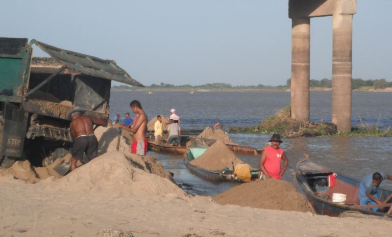
After three days we reached San Fernando, capital of the state of Apure. Under a tall bridge men were shoveling sand from steel canoes onto land and from there into trucks for transport. Further down thirty or forty boats were parked gunwale-to-gunwale, sterns riverward, bows on a steep beach littered with stranded water hyacinth. There was much hubbub of loading and unloading, coming and going. We landed among them and explored this metropolis of the plains. We soon located internet shops wherein we worked on keeping our U.S. internet purchases moving toward us. We had a new sail cover made and bought batteries. In a lovely plaza we found a government bookstore where intellectuals gathered. A poet/sculptor offered to get our writings into print if we translated them into Spanish. A historian told of us Simon Bolivar´s doings in Apure during the wars of independence. The store had a selection of Venezuelan literature, nearly free due to a program designed to boost literacy and revolutionary awareness. Steve selected several novels.


After three days San Fernando de Apure had given us all we needed so we continued downriver. It was hot and windy from the wrong direction. The river meandered a lot - for each straight-line mile we traveled 1.6 miles. But compared to the sea the travelling was easy! We averaged forty river miles per day. On January 21 mountains became visible to the southeast: the edge of the Llanos. A gap opened and the Rio Apure, which had seemed so huge, emptied into the Orinoco, a mile or two wide counting the islands in its braided course. Its blue-brown surface surged with upwelling currents. The land was drier now, more barren. The summer had started, and vast areas of sandy bottom were exposed, like deserts with blowing sand. We need to stay close to civilization until our package comes so we followed the Orinoco downstream a few miles to Caicara, a small city on the south bank where Steve spent three weeks in 1992. The friendly personnel at the little naval base are allowing us to keep our boat next to theirs for security. Later we hope to follow the Orinoco upstream to Brazil. We don´t have a good map yet but Ginny is researching how to make a GPS-readable chart using Google Earth.

We close with a homey detail that will put you right aboard with us. The awning is up. We have just eaten dinner. Steve reclines cleaning his teeth in “the throne,” butt on a cushion on the cockpit floor, back to aft bulkhead, facing forward. Ginny, resting from her culinary labors and fullness of belly, lays in bed, head on pillows, heels propped up on the companionway ledge, reading a book on our cell phone (since Steve sat on her Kindle). Steve pastes both toothbrushes, puts Ginny´s between two toes, says, “Toe-jam telegram!” and passes the brush from his toes to Ginny´s toes. She is now obliged to clean her teeth. Otherwise she might not get around to it.

More new photos in our Venezuela album.

Friday, December 23, 2011

December 24, 2011 - Puerto Cabello Venezuela, Mass email


Dear friends and family,

Happy Holidays!  Our gift to you is an email so long you can spend all year reading it, plus over 100 photos in the following albums:
https://picasaweb.google.com/ginnygoon/Colombia
http://picasaweb.google.com/ginnygoon/Venezuela


We last wrote to you from Sapzurro, a coastal village on the Panama/Colombia border, on the flank of the road-less, rainforest spine that joins Central and South America. Since then we have traveled hard to get as far east as possible before the stronger dry season winds arrive in December or January. According to the pilot charts, Colombia has the biggest waves in the Caribbean. And according to sailor legend the 400 miles between Cartagena and Aruba is one of the worst passages in the world. Refuges are few and the wind would be contrary. Needless to say we approached this coast somberly.

From Sapzurro we motored east across the entrance to the Gulf of Uraba. We lacked a mental picture of the Caribbean coast of Colombia. The land was low, rising to assorted hills, relatively dry. Roads and buildings were few, but the vegetation looked to have been modified by ancient clearings and cattle husbandry. 

The first night we sheltered in a huge mangrove lagoon, a maze of little islands and a haven for one of the largest populations of noseeums we have ever encountered. Our second refuge was behind a man-made breakwater in the town of Arboletes. The beach was crowded with kids playing soccer and men drinking beer under thatched roofs. The town on top of the bluff provided produce, bread, and internet service. No one paid us any attention. In each of the following days we arrived at a different set of low offshore islets. Rainstorms engulfed us: squalls of wind, then lightning and torrential rain, then clear sky again as we emerged on the other side. We learned quickly that our new raingear is as useless as the old. After six intense days we entered Cartagena’s vast outer harbor, a place of shipping and industry. From there we passed into the inner, historic harbor. 


In colonial times Cartagena was the principal port for ships arriving from Spain. To protect it the Spaniards built fortifications like what we had seen in Portobelo, but much more extensive. The Walled City retains hundreds of blocks of picturesquely dilapidated architecture, well appreciated by tourists. We anchored among the sailboats in the Inner Harbor, but there were too many wakes, so we moved to a place where local passenger boats were parked. For six bucks a day we got calmer water, security, and the convenience of being able to (sort of) wade to shore. We were sometimes woken in the dead of night by men paddling past in canoes while vigorously flailing the water with long poles, presumably scaring fish into nets.

Affluent neighborhoods abut the Walled City, but the bulk of modern Cartagena lays further inland. Here dust and vehicles choked the streets. Chaotic markets stretched block upon block. Music and hawking spiels blared from speakers. The days were the hottest yet. We walked the shady side of streets and detained our breathing to avoid fumes and stink. Garbage lay in heaps. From one pile Ginny selected a hefty stick forty inches long. When new it had been lathed to achieve a decorative shape, perhaps as a spindle in a staircase. When the staircase was demolished the spindle was discarded. It fit Ginny’s hand nicely, so she carried it as a club. In good neighborhoods she tucked it unobtrusively behind her backpack. In bad ones she spun it like a baton. Steve did not discourage her, having been mugged in Cartagena before. On the contrary, while Ginny menaced with her cudgel Steve’s right hand was likely to be toying with his folding knife. We’re hard-asses!

One day, while we were walking in a wealthy neighborhood adjoining the yacht anchorage, we passed a beggarly man carrying a big duffle bag full of junk. As he passed he grumbled, “Eso es mi palo!” (That’s my stick!”) He made no attempt to retake it. As he receded down the sidewalk we harkened back to the pile from which Ginny had picked up the stick. In retrospect it did seem to have been tended, as if articles of not-quite-zero value were placed there intentionally. We surmised that the junk man lacks a junk yard, so he leaves articles here and there, lets people know they are his, and receives a few coins through the honor system. Sorry junk man! We didn’t know! 


Our stay in Cartagena coincided with the city’s 200th Independence Day anniversary. For several days there were Marti Gras-like parades: tiger women, men in white tuxedos with pink hairdos. Boys covered with paint or grease threatened to smear themselves on passersby unless they donated a small coin. Change in hand we enjoyed the costumes and marching bands but mostly stuck to our errands and went to bed early. For much of cruising’s hard work occurs in ports, figuring things out, tramping from place to place.

We wished we could get transport to the Putumayo River, which flows into the Amazon. But it was way off on the Ecuadorian border, where guerrilla warfare persists. Then we noticed that Puerto Cabello, Venezuela is only seventy miles from a tributary of the Rio Apure, which flows into the Orinoco. If we could get to the confluence of the Apure and the Orinoco we could either turn left and come out the mouth of the Orinoco, as Steve did in 1991, or turn right, ascend the Orinoco, and take the Brazo Casiquiares to the Rio Negro, thence the Amazon. It is one of few places in the world where, due to a freak connection in their respective headwaters, one can navigate up one river and down another without portaging. Puerto Cabello was still 750 nautical miles away, but it was closer than Trinidad, which would otherwise be the end to our windward beat. 

Paperwork was a worry. Colombia requires that each time a boat, however small, enters a port having a Port Captain it must retain a shipping agent. The agent obtains entry and clearance documents for a substantial fee. As our friends say, “It´s a racket!” So we decided to bypass Barranquilla and Santa Marta, though they were on our way. And Venezuela has no ports of entry along our route until Puerto Cabello. So we got a clearance for Puerto Cabello, though it would take us weeks to get there. In the meantime we would have legally left Colombia and not yet arrived in Venezuela. Whenever we went ashore we could be violating immigration laws.

We left on November 12th, our 4th Escapiversary! The trade winds soon kicked in. We rarely sailed anymore. We motored past the gargantuan, hyacinth-choked mouth of the Rio Magdalena to a small town near Santa Marta. Here we got out and pulled the boat by hand into a knee-deep stream. A huge rain had just passed, so the current was swift. We had pulled Thurston a hundred yards up the right bank when suddenly the water level shot up and roller-coaster waves formed in the middle of the stream! We dug our anchors in to bank to avoid being swept away in the flash flood. The waves reared up tall and closely spaced, debris floating by at eye-blink speed. Suddenly the waves collapsed into a roaring brown foam. The process repeated itself over and over: waves growing to five feet in height, collapsing, and reforming. This furious rhythm slowly died during the night, until cricket chirps dominated. In the morning the flood was over. Egrets fished at the stream mouth. Thurston lay high and dry on the sand. Some fishermen woke us asking if we were still alive.  When we responded in the affirmative they helped us push Thurston back into the water. 

After Santa Marta the winds became stronger, the waves bigger. Sometimes even at full throttle we made only three knots. The propeller kept lifting out of the water, the motor stopping, but always restarting.  It made us nervous, especially since the strong winds make putting up the masts difficult and the shoreline was often rocky. So, we lowered the motor mount four inches. That stopped the cavitation, but it may have contributed to a close call when, after a hard day, we investigated a river mouth to see if we could enter it. While motoring back and forth studying the breakers Steve strayed too close. A wave broke over the lowered motor, drowning it! We quickly threw out the anchor, but in the minute or two it took for it to catch Thurston drifted further in. Waves kept filling the cockpit. The motor wouldn’t start. Deep shit. Steve quickly donned his swimming gear and swam in through the surf, maybe two hundred yards. 


Inside the river mouth fishermen were tinkering with nets and motors. A dirt road led into the town of Dibulla. Steve bluntly offered fifteen dollars to whoever would tow Thurston in. A skipper gathered up gas and crew while Steve nervously peered seaward. From where he stood Thurston and his wife were invisible much of the time, hidden in wave troughs. Meanwhile Ginny held on tight, but had prepared to abandon ship. The tall swells were breaking right on her. Some of them caught Thurston on her side, tipping one gunwale underwater while foam burst over the raised gunwale. Finally the skipper motored to Thurston, pulled her anchor aboard, and used the anchor line to tow Thurston. Coming through the mouth the towboat broached (turned sideways to a wave striking from astern) but apparently this was normal. Thurston was soon safe on a tranquil river. The sun set, the wind died. The mouth was calm when we left at sunrise.

As we traveled northeast around the Guajira Peninsula the dominant plant became a tall, scraggly cactus. The dominant insect was a green grasshopper with red legs, so big that on first sight Steve thought it was a green bird with dangling red tailfeathers! In stick-and-mud houses ashore or in wooden fishing smacks at sea the Guajiro Indians were quiet, undemonstrative. Wrecked ships dotted desert coasts on which boats cannot land, therefore there are no people: orange-tan cliffs and beaches with booming surf.

Our final night in Colombia we spent in Puerto Estrella, a bay sufficiently protected from the northeast swell to anchor safely but not comfortably. We bought gas from a woman who sold it in soft-drink containers from her house. Local gas comes illegally from Venezuela by mule. Following local practice we anchored Thurston bow-on to the swells and ran a stern line to a dead tree on shore. The surge caused a constant jerking forward and backward. The best defense was to lay flat on our backs in bed and wait for sunrise.


When it finally came we motored twenty-five miles out to Los Monjes, an archipelago belonging to Venezuela. The islands are little more than scattered pinnacles of rock except for the largest two, which are side-by-side. To create a base the Venezuelan Navy had leveled some pads and dumped the spoils between the two islands until they became one. No naval vessels were present but the barracks were full of sailors. We tied to a mooring rope. An ensign searched Thurston, chiding us for not carrying certain safety items for which we had no room. They even wanted to know if we had semaphore flags! Released, we hiked to the lighthouse and swam in the deep, crystalline water.

Again the wind decreased at night, so we left early for the Paraguana Peninsula, forty-eight miles away. The paired peninsulas, Guajira and Paraguana, were our principle obstacle on the way to Puerto Cabello. Much of the day no land was visible. Then we saw a faint blue mountain, then low hills. In the early afternoon we located Punta Macolla, where a half-dozen wooden boats huddled behind a small point, jostling in the swells. On the beach was a crude fishing camp. Beyond stretched flat desert.

To get around this second cape we left at 3:00 AM again. Our luck didn’t hold. An hour into the passage we hit a storm. The east wind picked up until salt spray blinded us and Thurston’s bow kept turning to one side or the other. We cowered over the compass, bracing against the belly-flops, hoping to break through to the other side of the storm. Then the fuel ran out. We refilled the tank, then Steve pulled the starter cord. Nothing! Water had gotten into the tank or the air intake. We deployed the sea anchor to control drift while troubleshooting the engine. Nothing worked. We needed to sail back to Punta Macolla. Working together we raised the masts, Steve lifting, Ginny wrestling the base of the mast into its hole. We unfurled a bit of sail and were soon back at the fishing camp with the sun rising.

Steve unbolted the motor and carried it into the camp, which consisted of a few plywood shacks and some tables made of broken-down appliances. The fishermen, swarthy men in their thirties and forties, drained the carburetor and changed the gas in the tank. They soon had it running like new, no charge. They encouraged us to wait a few days before trying the cape again, so we decided to sail south into the Gulf of Venezuela, where there are bays and towns.
 

Thirty miles south we found a small city. We were directed to the Club Nautico Cardon, a yacht club with a dock and dry storage for power cruisers. We moored among several tall, white sport-fishing boats. This being our formal entry, government officers searched Thurston again. The water was like a mill pond until a series of vertical waves suddenly rolled in, pounding Thurston against a steel piling! Two naval officers, caught while performing their search, fled in panic. Search over! We couldn’t bring ourselves to look at the damage.

A weekend-long fishing tournament was getting underway. More boats arrived. Excited crews prepped their engines and hauled beer and ice aboard. Merry-makers thronged the beach at the base of the dock. We relocated Thurston, bow to waves, stern to beach. She was safe now, but she jerked violently with each surge. Electronic Latin rap music blasted at all hours from multiple sources. We were depressed and uncomfortable. 

When the tournament ended the club members helped us. They hauled Thurston out, set her on a concrete slab among other boats, and gave us a power yacht to live in while we conducted repairs. After two weeks of sun, salt, and motion we craved the comfort. We had a hose, a power outlet, and we even found a weird, but functional shower stall in an otherwise broken back bathroom. We ate well and regained weight. The Venezuelans, respectful of our nautical spirit, were eager to lend a hand, a tool, or supplies. A shopping mall was a 25-minute walk away. Downtown Punto Fijo was a little further. There, on the black market, we exchanged dollars and Colombian pesos for Venezuelan bolivares. Venezuelan society seemed to be a boisterous free economy weighted down by an egalitarian but inefficient layer of Hugo Chavez socialism. Many of the Club Nautico members were critical of the government, but discreet. They talked politics with us just enough to reveal bitterness, fatalism.


The repairs took ten days. The port gunwale was badly broken at the leeboard pivot. The side deck had a split two feet long. We rolled Thurston over, gouged out disintegrated fiberglass, applied new glass and epoxy in a series of lay-ups, and replaced broken wooden parts. We restored her integrity and water-tightness and reduced her cosmetic scars to an acceptable level. 


The following day, as we finally rounded the Paraguana Peninsula, Steve sang the following song, the tune of which should be obvious:
Venezuela here we come, right back where we started from
You’re friendly, but deadly, we like it that way
Charged us too much money, but we‘re gonna stay, I tell ya
Venezuela here we come, because Aruba can’t be done
We are sailing into the sun
Venezuela here we come!


Ginny showed no pleasure in this, but she was equally glad to reach Adicora, a town with lovely old Spanish-Dutch buildings and calm water thanks to a protective reef. We next attained La Vela, on the mainland.  Since leaving Punto Fijo we had mostly sailed because our course was northeast, then southeast. From La Vela, however, we had to motor straight into the easterlies again.
Starting in the pre-dawn we droned through long days. The coast was endless, empty of people, covered with low shrubbery, green because the rainy season wasn’t over yet. We overnighted in Aguide and Chichiriviche, then crossed the still and seemingly endless Gulfo Triste to Puerto Cabello. We had problems - a broken lazarette hatch, a broken shear pin, ignition problems, etc. - but on December 14 we limped into Puerto Cabello, our goal for so long.


Since leaving Bocas del Toro we had travelled 1,500 nautical miles, far more per day than in previous phases. It was into the wind, but we had the motor, and the motivation. We had learned the importance of avoiding winds over twenty knots and waves capable of drowning the motor. Within these constraints, the motorized Sea Pearl is efficient, reliable, and fun. We love the challenge of doing much with little means.
We are now getting a certain extremely difficult permit. Then we hope to transport Thurston to the Rio Portuguesa, which connects with the Apure, Orinoco, Casiquiare, Negro, and Amazon rivers. If possible, our next country will be Brazil.  

Take care - we love you all.
Steve and Ginny


Wednesday, October 26, 2011

Sapzurro, Colombia Mass Email


 Dear friends and family,

We last wrote to you from Bocas del Toro, Panama, where we rejoined Thurston after four months in the States.

For the first couple days we stayed inside the muggy inland sea we had briefly explored in our shakedown cruise. Then we sailed offshore to a big, rocky island called Escudo de Veraguas. A scattering of shy or merely disinterested indigenous families live there. As we anchored at dusk the wind picked up from the south and rocked us around all night.


The coastline after that offered little protection other than small river mouths. Fortunately, the swells were small so we could enter anything with a foot of depth. The Isthmus of Panama is narrow, tall, and heavily forested. Most of the villages have no communication with the outside world except by coastal boat. We stayed at a place called Calovebora a couple days. It had two stores and a school. From the village various small trails radiated out to coastal landholdings where the people had erected fences to keep cattle from falling off the seaside cliffs.


Our next stop was the Rio Belen, where Columbus had to abandon a ship on one of his voyages. We rowed upstream two miles before settling for the night. We came to native community consisting of six primitive houses spread over some cleared hills. They had cattle, pigs, chickens, and dogs. They kept their dugouts in a little tributary ravine. With their permission we parked there also. The many curious children took advantage of the ravine’s steep banks and climbing trees to perch themselves overhead and comment upon our every move. They gave us plantains to eat, and a strange wild fruit that is like a large bean with a woody husk. The edible part is a sugary white fur around the hard black “peas”. We shared our cookies, and that’s a big deal for us!


We also explored the Rio Chagres, a wild river with no sign of man along the banks. Six miles up we reached Gatun Dam, where the river’s flow is impounded to power the locks in the Panama Canal. From the foot of the dam we walked up to the edge of man-made Lake Gatun. To our left were the upper Gatun locks. The lake was full of Atlantic-bound ships waiting to go through. The sea on the Caribbean side was full of anchored ships waiting to transit to the Pacific.

We sailed past the Panama Canal entrance to Portobelo, a day’s travel away. Portobelo is the harbor in which the Spaniards used to load their treasure fleets with silver and gold. The ancient forts still stand, their cupola-capped sentry booths intact, cannons still protruding from the embrasures. The town is small but boasts the cathedral in which stands the statue of the Black Christ, which many worship. Thirty-odd sailboats from all over the world lay at anchor.


We stayed for six days getting things done, including a trip to Panama City. There it took us hours to find a certain upholsterer to repair our awning. The buses were crowded and slow due to traffic congestion. Hating taxis we got off in the general area and looked on foot, but there were no street signs or address numbers. When we finally found the place indicated on the web site it turned out that they had moved six years before! A good Samaritan phoned the upholsterer, who came and picked us up. We three drove all over gathering the correct cloth, thread, and needle. His shop was a converted house, very messy, in a residential area. At 9:00 PM he finished the repair, cleared off a couple of couches for us sleep on, showed us how to lock the door, and left. In the morning, before anyone showed up for work, we walked to a nearby bus stop and started the grueling return to our boat.

Panama is 400 nautical miles west-to-east. Portobelo was the halfway point. From there to Colombia we passed through the San Blas Islands, land of the Kuna Indians. The coastline remained mountainous and roadless. Some of the islands were hilly, others mangrove-y. The sonorous howling of monkeys was never far distant. Birds made many strange cries. The Kunas maintain a traditional lifestyle. Many of the women still dress in their colorful traditional garb. Their homes are of stick and thatch, their boats are motorless dugouts. They live in dense villages, not in scattered homes. In one bay we passed six small, low isles, all entirely urbanized, like a Kuna Venice.


We mostly slept undetected in out-of-the-way places, but one evening we pulled into a small river mouth a half mile from a village. All the males of the village immediately ran over to us. They spoke excitedly in Kuna among themselves, Spanish with us. One said we had violated their law by entering the mouth. If we didn’t pay a fine of $50 the policia nacional would be called. (Panama uses U.S. currency.) “No, a hundred dollars!” cried another. Finally the Autoridad Maxima arrived, the oldest man in the village. He was a small, slender man with smooth, honey-colored skin and cataract-covered eyes. He wore faded brown slacks and an old Tyrolean hat with a little feather. Perhaps due to near blindness it took him a while to get his bearings. Finally he rendered his verdict. “One hundred fifty dollars!” Everyone laughed, for the people were jolly as well as mildly hostile.

Steve, after various defenses, hit on a proposal. “Okay, we will leave at once and sleep in front of your village. Whoever wants to can come with us so you know we won’t escape. In the morning the policia nacional can come and sort it out.”

This suggestion seemed to disappoint them, perhaps because they were more interested in money than getting the police involved. However, a ride in this strange and wonderful boat was not to be scoffed at, so five, including the Autoridad Maxima, climbed aboard. The latter sat on a side deck tapping this and that to see what it was made of. The others laughed and chattered. Steve rowed to the village where we anchored bow to shore, stern to sea. Fortunately there was only a mild surge. Steve waded ashore and interacted with the massed villagers. Fines were no longer mentioned. The schoolteacher taught Steve the Kuna word for “alright:” “Neuti.”

 “Neuti?” Steve asked the people to his left. “Neuti?” he asked to his right. “Neuti,” they said, the women smiling shyly. They wore bright, hand-crafted clothing with leggings like stacked beads. We retired and left early in the morning before many were up, at the advice of a village elder.


The wind was from the south. It came over the mountains in eddies and gusts, always too much wind or not enough. We now saw a new species of coastal freighter: clunky wooden double-enders that come from Colombia. A friendly mass of porpoises led us to a towering green mountain which tapered to a point called Cabo Tiburon. We had reached Colombia! Just past the cape was a steep-sided cove with a village called Sapzurro catering to Colombian tourists.

The civil war is over; Colombia is safer now. The snorkeling and hiking are great! When walking the path from the anchorage to the village we have to be careful not to step on crabs or huge frogs. The stars are bright at night. We have been here three days. Soon we will sail across the opening to the Gulf of Uraba and continue to Cartagena.

The new outboard motor is working well. We are glad we didn’t get one at first because it allowed us to develop our sailing skills and work out bugs in the rowing station. But starting in Honduras we had felt the lack, because we increasingly encountered headwinds and a lack of harbors. Thurston rocks a lot in waves, so you can’t just stop in the ocean and go to sleep! From here we face about 1500 miles of upwind sailing, so in Bocas del Toro we installed the Honda 2HP. It has been a challenge to find places to stow the gas tank, oil, funnel, etc. Ginny is averse to the smell of gas so we have to wash with soap and wipe with vinegar everything that come into contact with gas.

We always sail on fair winds (3/4 of the time so far). We row if there is no wind (1/8 of the time). We motor straight into headwinds (1/8 of the time). When we get to where we can sail to our destination without tacking we kill the engine. We also have the option of motoring up rivers, which is fascinating. The motor has boosted our confidence. We choose destinations that are further away, knowing that headwinds won’t thwart us. We feel like we are cheating, but it is fun to cover more ground.

When Steve was promoting Three Years in a 12-Foot Boat he was once guest in a radio talk show in which the other guest had just written a book about extreme outdoor challenges. His thesis was that due to modern technology the only remaining challenges are those in which the adventurer purposely makes it harder on himself, such as by climbing without oxygen or sailing in a ridiculously small boat. Steve protested that his situation was different. In his home life he is a minimalist and an ecologist. He doesn’t burn fossil fuels very much or live in a big house. He just carried that philosophy over into his adventuring. The motive for doing something “the hard way” may be environmental or spiritual, not vanity.

We both honor the nature we are sailing through. We’re sorry we have to start the motor now and then, and we feel like “wussies.” But we are having a great time!

Enjoy some new pictures at https://picasaweb.google.com/ginnygoon/BackinPanama#
Take care - we love you all.
Steve and Ginny


Saturday, October 1, 2011

Bocas del Toro, Panama - mass email


Dear friends and family,

We last wrote to you from Stone Mountain, Georgia at the end of our summer sojourn in the States. On September 7 we flew from Atlanta to Miami, then Panama City. For two days we rode buses, taxis, and boats getting ourselves and our seven items of luggage back to Bocas del Toro, where Thurston awaited us. She lay on land in a marina and was in good shape. We installed the new motor mount, 2 HP outboard motor, gas tank, sails, and scuppers to drain the side decks. We also painted and fixed various components.


It’s hot and buggy here, but we defend ourselves with an array of creams, cloths, and coils. To get to town we either paddle our inflatable kayak, take a water taxi, or walk around an intervening bay along the mangroves. There the smell of briny ammonia is powerful, a product of decomposing vegetation.


For four days we cruised the nearby islands while trying the new installations. The winds were light so we quickly got in the ten hours of motor time specified prior to performing break-in maintenance. We navigated a complex pattern of low islands and hilly peninsulas, narrow passages and open sounds. Our favorite nocturnal tie-up was in a small river with a forest to one side and a field populated by Brahman cattle on the other. It rained all night, and the freshwater streaming over and under us smelled clean after so much salt.


We circumnavigated Isla Cristobal, and on Isla Bastimentos finally saw sloths! One, presumably the mother, was 50 feet away in a tree. The baby was only six feet away with its back to us. They have long, coarse fur (an entire ecosystem within it!) and don’t move much. Ginny says they must be hyper-intelligent because they have so much time to think. An acquaintance here who once picked up a baby (they “walk” on land sometimes!) and looked into its eyes felt otherwise. Steve isn’t taking sides, even though the sloth is Ginny’s totem.  He thinks the connection is that they both excel at leisure, but he’s missing the point completely!

We have now debriefed from our shakedown cruise and are leaving in the morning. Our sailing permit says our next port of call is Portobelo, on the far side of the Panama Canal, but we will stop in small bays and rivers along the way. Further east still lie the San Blas Islands and the coasts of Colombia and Venezuela. After a five-month intermission we are ready to resume our voyage.

Enjoy some new pictures at https://picasaweb.google.com/ginnygoon/BackinPanama#

Take care - we love you all.

Love,
Steve and Ginny