Friday, December 24, 2010

January 7, 2011 Mass Email - La Ceiba, Honduras


Dear friends and family,

We last wrote you from Lago Izabal, Guatemala. We haven’t gone far, but two months have lapsed. So here’s an update.

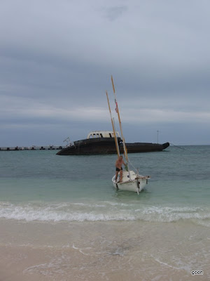
We sailed back to Livingston, where we cleared out of Guatemala. Then we began coasting along Honduras, which has very few harbors. The distance to the next is often too great to reach in a day and there is much uncertainty due to fickle winds and heavy swells which may or may not block entry into the various river mouths. On November 4, 2010 we entered the Rio Motagua, wilderness boundary between Guatemala and Honduras. Surf was breaking on the sand bars at the river mouth, but we found a channel deep enough for the swells to pass without toppling. Halfway in we jumped out to walk the boat through, the waves knocked us around trying to release Thurston from our grasp. Once inside we hid in a swampy side channel and slept among tall grasses growing in the water, near a tree in which white storks were roosting. Crabs, crickets, and cockroaches climbed aboard from the surrounding vegetation, requiring many minor evictions.


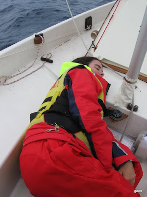
The next day we cut across a large bight toward Puerto Cortes. The wind slowly built up to 38 knots, as we later learned from the port authority. We had never experienced this much wind, and were a bit frightened. We rolled our sails until each was the smallest possible triangle, and still we shot through the bounding seas at over six knots. When we reached Puerto Cortes our worries weren’t over because it is unprotected in a west wind. We anchored near shore while deciding what to do. We decided an inlet visible to us was passable, but we were now unable to pull the anchor in against the wind. Waves were breaking over the bow and we were quite uncomfortable;. Finally Steve strained at the oars while Ginny pulled the line. Inch by inch we moved forward until the line was almost vertical, then Ginny tied off. The anchor had buried itself firmly into the bottom, but after ten minutes the lifting waves broke it loose. We sailed into the inlet, removed our masts, and rowed into a tiny creek within the naval base that occupies a portion of the harbor. We were so happy to be safe and comfortable! The naval personnel allowed us to leave our boat there for two days while we cleared into Honduras and waited for the storm to blow over. But they wouldn’t let us sleep aboard, so we sojourned at a $10-a-night hotel while the corrugated steel of nearby roofs rattled in the gale.

The next harbor was Laguna Diamante, in a remote national park thirty miles east of Puerto Cortes. The coast is generally low but here a sharp spur of mountain juts out into the ocean. Midway along this knife-like ridge was a fifty-yard-wide gap with seas breaking heavily on both sides. We shot through this opening and found ourselves in a large, calm lagoon bounded by the reverse slope of the ridge on one side and by flat mangrove on the other sides. There was no sign of people except an unoccupied thatched hut. We rested tranquilly and hiked the trails and beaches.

The next day the wind was still blowing hard through the opening, the seas still crashing heavily on the rocks to either side. This is one case where a motor would be nice! We sailed gingerly back out through the opening, straight into the wind, in series of short, nerve-wracking tacks. Then sailed around that mountainous cape to the town of Tela. A heavy swell was still running so it wasn’t possible to enter the little creek that debouches there. To get a good night’s sleep we anchored outside the surf and swam into town with a waterproof duffle bag containing clothes and necessities. Then we wandered the streets in our swimsuits, snorkels still wagging on the sides of our heads, and found a cheap hotel and an internet café. At the latter we studied again, via Google Earth, the many stream mouths which may or may not be safe to enter, depending on the swell.


Unfortunately there would be no sure thing before La Ceiba, forty miles away. The island of Utila was closer so we decided to go there first. The wind died yet the sea remained rough, a difficult condition in which to row. Then a favorable though constantly shifting wind sprang up. Night and heavy rain squalls closed around us before we could see the island. We sailed blind, watching our compass with our headlamps, studying the GPS. The rain found its way past our foul weather gear, and Ginny became cold. Finally we started seeing lights. They grew and clarified until around 10 PM we entered Utila’s harbor, turned right, and found protected shallow water within wading distance of land.

Utila is the westernmost of the Bay Islands, famous for their coral reef diving and unique social blend. Like Belize, the islands were settled by Englishmen. Their descendants still speak English, as do most of the tourists. The accents range from lilting Caribbean to flat American. Many Spanish and Garifuna-speaking Hondurans have also moved here, attracted by the tourism and fishing industries. The island has one town, occupying the foreshore of the half-moon bay in which we were anchored. The town is shaped like a new moon, slender and curved, because beyond a narrow strip of land the interior consists of mangrove swamps and steep hills. We stayed here five days, resting from our travails at sea. The weather remained cool and rainy. We explored the island’s rough dirt roads on foot, and snorkeled a coral wall with Captain John, a retired Bostonian sea captain who reminded us of a serious Mr. Bean.

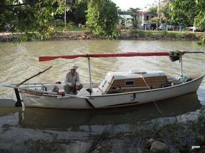
Several problems with Thurston having come up, we asked Captain John where we might conduct some boat work. He recommended the La Ceiba Shipyard. So there we went, an easy twenty mile crossing. The mainland was a wall of steep, lushly forested mountains with a narrow plain facing the sea. The town sits at the mouth of a small river, but the harbor is a mile further to the east. We entered through a pair of jetties. Inside was a small anchorage and a complex of docks thronged by steel fishing boats. From this central body of water radiate several quickly-tapering mangrove creeks. The La Ceiba Shipyard occupies a peninsula between two such channels. We moored to one of their docks for a week, then had the shipyard workers move Thurston into their yard with their Travelift.


La Ceiba, population 130,000, grew up as headquarters for the Standard Fruit Company, and is the gateway via ferry to the Bay Islands. We went into town every two or three days by walking a mile-long dirt road then catching a bus which costs only 5 ½ lempiras, about $.30. The downtown is a large grid of busy streets with unremarkable architecture, a neglected central plaza with trees and the busts of heroes, and a crowded market district. In the coming seven weeks we walked all over it in search of things needed to advance our voyage. Here the pedestrian must take care because the sidewalks are discontinuous and encumbered with vendor stands and hazards such as utility vaults with missing lids. There are far too many taxis and they all honk at you far too much in hope that you will want a ride! Being stubborn penny-pinchers we cut a wide swath of crestfallen taxi drivers. We got to know the local hardware stores, supermarkets, and ATMs. After some disappointments we settled on a favorite restaurant, the Cobel, which efficiently serves the typical fare of meat, rice, beans, and fried plantains.


The shipyard has an office, chandlery, restrooms, and repair shops. On its flat gravel surface sit perhaps thirty commercial and recreational boats. Some are under repair, some in storage, some abandoned. Most activity centers around the big steel shrimpers and lobster boats. Welding torches are forever sparking and crackling, and much bottom paint is applied with rollers on long handles, for the boats are quite tall up on their blocks. The sailboats and power yachts sit further in back, where less work occurs. During our stay several American and Europe crews came and went, or returned from abroad to retrieve their problematic investments. For a shipyard is but a concentration of boating woes: Each vessel is a unique expression of its past and current owners’ dreams, all frustrated or at least postponed by dry rot, collision damage, mechanical failures, and defunct electrical systems. We made some friends, particularly Hal, who had bought a beautiful wooden pilot cutter from its distressed owner and lives aboard at the dock, and Mark, whose large, powerful catamaran was undergoing maintenance.

For us it was the usual story. We’d thought our last stint of boat work had earned us much uninterrupted sailing time. Alas, more deficiencies had surfaced. And the haul-out, by making Thurston easier to work on, induced us to undertake more jobs than we would have otherwise. Materials availability and shipping connections were good here, too.

Some debugging of the work we’d done in Georgia still remained and Thurston’s bottom required maintenance. Hundreds of tiny gel coat blisters had appeared, indicating water penetration. There were gashes from hitting rocks, and the bottom paint was worn off where we had grounded on beaches. We replaced our cushions and our awning too.

Finally, with help from Ginny’s mom we acquired new equipment. We bought things over the internet and had them shipped to Lois’ house in Los Angeles. She consolidated them and had them shipped to us in La Ceiba. Thus we obtained an inflatable kayak (our inflatable dinghy was too bulky), a single-sideband radio receiver for weather forecasts, charts of the coast from Honduras to Colombia, headlamps, shoes, and a backup handheld GPS. Mom Lois also included little gifts and decorations to enliven our Christmas, for we spent that holiday, as well as Thanksgiving and New Year’s, in our camp at the shipyard.


We called it Camp Drip. The bottom work required that we turn Thurston over, so we had to sleep in our tent, and the frequent rains necessitated shelter. So we moved Thurston under a huge, dilapidated catamaran. Here, on the gravel between the twin hulls, we had room for boat, tent, one makeshift table for cooking, another for chemicals, a pair of saw-horses, chunks of wood for sitting, and buckets for catching drips, the structure overhead being perforated with drain holes. (It was also so low that Steve had to walk around with his head cocked to one side.) Puddles formed during the rains and dissipated afterward. We learned where we could set things and where we couldn’t, where to walk and sit without getting showered. The roof dripped even when it wasn’t raining because the central portion of the catamaran had filled with water, the drains having partly clogged. We had a leaky swimming pool over our heads! One day Steve climbed up and poked the holes clear. It took a day for all the water to drain!

We gave an old radio to our daytime security guard. He reciprocated by bringing us fruit from a nearby tree. The size of large radishes and similarly colored but with a pit inside, they taste a bit like sour apples. José was an open and innocent young man, reverently friendly, with a cherubic face and bright eyes: Though the radio we’d given him can tune in stations from all around the world he was interested only in the local evangelist channel. He sang along to the Christian songs.

On Christmas Eve a small, white, long-haired dog showed up at Camp Drip. At first he was leery, but soon he adopted us. Initially depressed-seeming, under our care and feeding he flowered. Now rather than cowering he cheerfully trotted to and fro, following us everywhere and was eager to play, for he was quite young. Not wanting to name him, exactly, we called him Little Dawg. He slept outside our tent and barked at approaching strangers. It was hard to leave him, but we found him a good home with a fenced yard where he can run and play, free of the usual Honduran dog’s three foot leash.

Our work was done. On the night of January 6, 2011, five of us from the shipyard dinghyed across the channel to the more populous west side of the harbor. Here, among a cluster of shacks, was a sort of tiki bar / restaurant. Our friend Hal had provided the only decoration to date, a collection of country and signal flags that had come with his boat. Mark contributed a string of lights in the form of colorful little palm trees. Julio, the owner and often the only worker, was jubilant. We had come here many times. We had seen him wrestle a dead-beat into the street when he refused to leave, and cook fine meals with little means. He was a small, lithe man with bronze skin, a dramatic manner, and tousled graying hair. This night he played ballenato and meringue music on his stereo, and showed us how they dance such styles, simpering and grinning his funny V-shaped grin, lips slightly pursed. Three of us didn’t get what we had ordered, but the food and Salva Vida beer was all great and we didn’t care. Tomorrow we leave.

See the rest of our new pictures in our current photo album: http://picasaweb.google.com/ginnygoon/Honduras# and a few new ones in the prior Guatemala album: http://picasaweb.google.com/ginnygoon/Guatemalaaa!#

Also, check out the Jan/Feb issue of Small Craft Advisor for the second in our series of articles! You can subscribe here: http://www.smallcraftadvisor.com or view the electronic issue.

Hope you all have the most amazing Uncle Bill/Lena Fantastic/David Bowie birthday weekend ever, celebrate it like you never have before!

Love,
Ginny & Steve

Saturday, October 30, 2010

October 30, 2010 Rio Dulce mass email


Sorry we haven't done any blog updates in so long! Please accept this excessively long mass email as our apology:

10/30/10

Lago Izabal, Guatemala

Dear friends and family,

While cruising this huge freshwater lake in Guatemala we realized it’s been two months since we emailed you about our travels. So here’s an update.

You’ll recall that we got married on Caye Caulker then spent two weeks at Turneffe and Lighthouse Reefs, the atolls furthest out. Then we sailed to Belize City where those awful boys threw rocks at us from the bridge. From there we navigated south through Belize’s southern waters.


First some basic geography. The coast runs north and south. The land is flat and mangrove-edged. Lying immediately offshore is a shallow open channel five to ten miles wide. Then there is band of similar width containing dozens of small, flat islands. Many are only mangrove trees rising from water, not real land. These islands terminate at the barrier reef, which is a band of dead and/or living coral, beyond which is the deep Caribbean Sea. The sharp coral heads rise right up to the surface and the ocean swells break on them. It is possible to exit the reef only at certain passes.

We are most interested in the area near the barrier reef because the water is more clear there, for better snorkeling. So we travelled south through the islands, sometimes coming right up to the barrier reef and swimming in the passes. These are the supreme dive spots because they have lots of sea life and grand underwater scenery.

We can carry enough food and water for only two weeks, and the fruit and vegetables give out much sooner since we don’t have refrigeration. So we returned to the mainland at three places to reprovision.. The first place was Dangriga, also known as Stann Creek for the creek which debouches there.

We last wrote you from Dangriga on August 20. The place is relaxed and funky, but it has some of the same aggressiveness you find in Belize City. For example, one day we were walking to the library when an elderly Creole man raised his arms to us in an embracing gesture and proclaimed, “My brethren! I have coconuts for you!” We told him no thanks, nonetheless he scurried around gathering up machete and coconuts while expressing great love for us and chasing us down the street. We entered the library, ready to do some research or other. As we were sitting down he grandly entered with an opened coconut and held it in front of Steve’s face, saying, “Take it, take it!” Steve’s resistance faltered. It did smell good. He took a sip of the cool, faintly sweet coco water. “I’m sorry, no food or drink in the library,” said the librarians. With some foreboding, Steve went out to the porch, finished the coconut, and offered the man fifty Belizean cents. “Two dollah U.S.! Two dollah U.S!” The vendor screamed, no longer fraternal. Steve refused to pay any more and went back inside. The guy remained outside, ranting against us for some time. We bring this up because Dangriga seems to be the southern limit of the hard hustle zone. Nobody has hassled us that like since!

Getting out the mouth of Stann Creek was tough. There was a strong onshore wind. The mouth is too narrow to tack out with our sails, so we kept the masts down to lessen wind resistance and rowed over the bar. It was hard to make any progress; the boat kept wanting to turn sideways to the waves. We anchored to keep from being blown back onshore while raising the masts. The sea was rough. A wave broke over the boat, filling the cockpit. Steve stood with his legs wide apart on the foredeck. Ginny got low and gripped his belt from behind, forming a tripod. Steve hoisted the mast vertically in a series of upward shifts and dropped it into its socket. We repeated with the mizzen. Then we sailed hard into the wind until we reached the chain of islands.

The islands from Dangriga to Placencia were somewhat familiar to us from our time in Belize two years ago. Among the many islands we visited was Wee Wee Caye where Paul and Mary Shave (who we had met two years prior) operate a marine research center. Unlike other island developers they have retained the fringe of mangrove trees and use boardwalks to connect the docks with the buildings in the center of the island. Because of this it is possibly the nicest inhabited island in the area. At the time of our visit there was a group of researchers from Boston University who were investigating the dispersal patterns of reef fish larvae.


Belize’s southern waters differ from its northern waters in that they are deeper, often around sixty feet, but contain numerous, steep-sided near-islands (underwater hills). Their flat tops are within a few feet of the surface so they appear as shoals. The locals call them faros. Our theory is that the islands are merely faros which are slightly above rather than slightly below sea level, and that all are of coral origin. In effect, each is a tiny atoll. The southern waters are also different in that live coral is found around many of the islands and faros, not just out at the barrier reef.

The winds died, as they sometimes do in late summer. We spent days rowing in excruciating heat with the tarp up to block the sun. Steve’s itchy bumps, which we later realized was heat rash, got worse. We reached the barrier reef at the Silk Cayes, and snorkeled our usual one to two hours per day. Then park rangers told us we were in a marine reserve and would have to pay daily fees, so we left.

Next we restocked at the mainland village of Placencia, where we made friends with an amiable couple who allowed us use of their dock and took us to a Town Council meeting. Turns out council meetings are mind-numbingly boring wherever you go! After three days we went back out and followed the islands to their conclusion. We sailed to Ranguana Caye, on the barrier reef, and south along it to its southern terminus at the Sapodilla Cayes, which is a widely dispersed group twenty miles from the mainland. These are real islands with sand and coconut trees, not just swamp, which is refreshing! The winds were light, and it was hot twenty-four hours a day. For weeks the temperature was in the 90s by day, and in the 80s by night with no breeze to cool our sweat-drenched bodies.

How to anchor at night was a quandary. We needed shelter because Thurston rocks uncomfortably in even small waves. The islands, often no larger than a football field, provide wave protection from only one direction. In the night the wind usually changed direction, and there were often violent thunderstorms. The boat would rock and we would roll around like ragdolls in our 3’ x 8’ bed (Ginny with her head forward, Steve with his head aft, our legs overlapping).

The bugs further complicated our anchoring. We wanted to sleep with the bow nudged right onto the sand to get the most protection from the island, but that put us closer to the mosquitoes. Even anchored several hundred yards away they would find us, meaning more time in the cabin, which is protected by a mosquito net but which is hotter than the cockpit. On Carey Caye we anchored on a seemingly bug-free shore. Then the nightly lightening storm hit. When the rain stopped the no-see-ums came out. They are small enough to crawl through the mosquito net, so we had to keep mosquito coils (aka poison incense) burning. Rocking, heat, or insects often kept us awake at night, making this the grouchiest leg of our tour so far..


Punta Gorda was our final stop. Our ninety days worth of visa in Belize were nearly over. PG is an orderly little place, at the end of the paved road that runs south through Belize. The Mayans in the surrounding villages grow cocoa beans. We saw sacks full of them in a little warehouse which Steve weaseled us into by the magic words “My wife wants to see some chocolate!” We were offered a handful of the germinated, dried beans. They are the size of a thumb, with the texture of a date the taste of raw chocolate. They sell their entire output to Cadbury’s, so next time you eat a delicious Caramello think of us pawing your chocolate beans thousands of miles away!

The Mayans are capable of mayhem as well. At a Catholic revival meeting in the town square we heard references to “the lost children.” We found the story in the local paper. Five days before a Mayan brother and sister, both under ten, had been sent into town to sell limes and had never been seen again. A woman purporting to have soothsaying powers said the American couple with the center for the rescue of endangered crocodiles a few miles from town had fed them to their crocodiles!. A busload of armed villagers hurried to the croc farm. No one was around, but they found limes! So their burned the place down and slaughtered crocodiles. The woman had subsequently been arrested for “pretending to be a fortune-teller.”


We completed the tedious exit procedures and rowed south across Bahia Amatrique seventeen miles to Livingston, Guatemala. The sun glared on the flat sea as we took turns rowing. The blue mountains of Honduras and Guatemala grew closer. We rounded a headland and entered a wide, tropical river mouth, on the right side of which is Livingston, a town which is only accessible by boat.

Livingston is steep and lush. The waterfront a jumble of docks and buildings. We tied to iron bars jutting out from an abandoned factory and completed our paperwork for a ninety-day visa. The cultural mix is Latinos (Spanish speakers), Mayans, and Garifunas, (blacks with their own language.) The restaurants were cheaper than in Belize, typically something like 20 quetzales, or $2.50 US, for a poor man’s meal of egg or a bit of beef with beans, rice, and maybe some sweet plantain. The women wash their clothes in a charming municipal facility that consists of a roofed, ankle-deep pool with a double row of concrete scrubbing surfaces. Here the ladies enjoy coolness and each others’ company while doing their laundry, without polluting the river (or their wash) which is how it is normally done.

Livingston is at the mouth of the Rio Dulce, a name we’d being hearing about since our exploratory trip through Belize in 2008. Though not generally well-known, it is famous among yachtsmen as a hurricane hole and good place to store boats. Most of the boaters we’d met since leaving the States had been here or were going here. It is a short river. About seven miles separate it from El Golfete, the first lake. Then there’s another couple miles of river, about which is Lago Izabal, a lake twenty miles long and ten miles wide.

It took a day to sail and row up to El Golfete, straining against the current. The river flows through a deep, winding canyon with sheer, forest-draped walls. We passed boys in dugout canoes tugging hand lines. Upon reaching El Golfete the shoreline became a low, swampy forest. The next day we continued to the section of river between El Golfete and Lago Izabal. Here a highway crosses the river via a long bridge. The town of Rio Dulce is on the right, or northwest side.


We walked the town. It is small yet crowded: one long narrow street packed with ramshackle stores, cattle trucks, motorbikes, and Mayan women in traditional garb selling street food. One has to squeeze through all this to make any headway. Meanwhile one’s nose it accosted by dust, diesel exhaust, and the smell of many braziers cooking chicken and other street food. At the end of town the highway continues north through the vast forests of eastern Guatemala, eventually reaching Flores and the ruins of Tikal. In the other direction the highway connects to Honduras and the higher, more populous regions of Guatemala.

The mainly North American and European yachts in the Rio Dulce are housed at a dozen or so marinas between El Golfete and Lago Izabal. Most of their owners leave them in storage there, some live aboard. We tried saving money by staying at a public dock under the bridge, but someone stole our anchor, chain, and 200 feet of good nylon braid.

Needing better security, we opted for La Joya del Rio Marina, on the southeast side of the bridge. It consists of rough plank docks and a large common area consisting of a roofed, wooden deck, wall-less except for bathrooms, kitchen, and a few shops and cubby holes. The place had once been a hotel, restaurant, and bar in addition to a marina. It is built entirely over water, the surrounding land being forested swamp. The family who runs the marina, the dozen or so live-aboards and the Guatemalans who work for the marina or hired themselves out for boat maintenance form a small community which was quick to welcome us. Steve set up a mosquito net over a chair in the common area and often had the place to himself for reading after dinner. Though the others got to town via their dinghys, we got there by wading through a swamp, crossing a field, cutting through a school yard, and walking across the half-mile long bridge. It was always a contrast to go from the semi-deserted marina to the over-crowded, noisy town.

The marina was a good place to get things done. We found a new anchor and related gear. We re-varnished and painted, including some new green enamel accents. The rowing seat broke, so we made a new one out of epoxy, fiberglass, and aluminum plate. The mosquito net that covers the cabin door tore. We made one of those too. We’ve lived aboard for ten months, and our boat work has slowly shifted from de-bugging to maintenance and minor improvements.

Steve decided to ship his accordion home and buy a guitar. The accordion was too hard to get in and out of its storage place and there was no comfortable position to play it onboard. He’d never played the guitar but didn’t mind learning. So we took a bus to Guatemala City. It took almost six hours yet cost only $7.50 each. We stayed at a good $14-a-night hotel in the historic district and walked and bussed all over the city checking shipping agencies and music stores. We also got new binoculars, T-shirts, and shoes.

We enjoyed Guatemala City. The weather was refreshingly cool. There is fine old architecture around the Plaza Mayor, which is like a smaller version of Mexico City’s Socalo. Vendors crowd the many market districts. There is a vast auto repair district, a jewelry district, even an extensive bridal gown district, with storefront after storefront of mannequins wearing gaudy nuptial clothing. It was so cheap we treated ourselves by going out to movies and drinking beer in a Chinese restaurant that doubles as a low-class sports bar. We were there a week, and felt we got to know the city fairly well.


Back at Rio Dulce we finished up some boat projects, then cruised Lago Izabal for ten days. There was little wind, so we rowed west along the north shore of the lake to the town of El Estor. Forested mountains ring the lake, yet the banks are often low and wet. We camped in little coves and creeks, and explored the mouths of the Rio Polochic, where howler monkeys were visible, and certainly audible, in the big trees along the swampy banks. We visited a Mayan village where the people live in plank-and-thatch houses. Everyone was at the soccer field by the church, where a match was underway. The players wore standard team uniforms. The women wore full, shoulder-strap blouses and long skirts of intricate hand-woven fabric. The disproportionately numerous toddlers wore nothing at all!

Now we’ve wrapped that up and are ready to proceed toward Honduras, whose coast runs for about four hundred miles east into the prevailing trade winds. In anticipation we shopped for motors and were even delivered a motor mount as a wedding present from Marine Concepts (the manufacturer of Sea Pearl boats!) Our emotional and mental block against the hassles of a motor has yet to crumble however, so we’ve spent a lot of time studying the maps to determine the longest distance we may have to go in a day. Turns out for the first half of the country at least there are plenty of little river mouths we can duck into for the night. So, we’ll continue on as we are! We look forward to exploring Honduras and the Bay Islands and plan to leave here on Monday, our four month anniversary and 12 days before our three year escapiversary!


There are lots of new pictures in our current photo album: http://picasaweb.google.com/ginnygoon/Guatemalaaa# plus some you haven’t seen yet in the prior Belize album: http://picasaweb.google.com/ginnygoon/BelizeFinally# (starting with “mangrove madness.”)

Also, check out the Nov/Dec issue of Small Craft Advisor for the first in our series of articles! You can subscribe here: http://www.smallcraftadvisor.com or view the electronic issue.

Hope you’re all doing splendidly and sorry about the length of this update. We sort of promise to try and do them more often with less length!

Love,

Ginny & Steve

Monday, August 30, 2010

August 20, 2010: Dangriga mass email


Hi Everyone,

You last heard from us just after we’d arrived in Belize two months ago. We’re about half way down the Belize coast now. Much has happened.

We visited our Oregonian friends in Corozal, in a big bay on the Mexican border. Then we sailed back out to the cayes (Belizean for islands, pronounced “keys”). We got to Caye Caulker four days in advance of our wedding and started preparing. We parked our boat on a shallow shore at the south end of the island, where our people had reserved small rental houses. We slept aboard except for when Tropical Storm Alex hit. That night we took the precaution of staying in a cheap bungalow. High winds blew all night and the sea level rose. Coconut tree branches broke off and flew around. In the morning all was peaceful again.

Ginny’s friends Lena, Jesse, and baby Violet Fantastic arrived first. They had flown to Belize City the day of Alex and had to hole up there. The next day they came to Caye Caulker by “water taxi.” Then Steve’s cousin Kristy and her husband Dave came and occupied a second house. Ginny’s mom Lois came, then her sister Carley from Seattle. They moved into a cabin. Steve’s mom, dad, and sister (Bonnie, George, and Susan) stayed in a house on the same property with nice gardens around it. Finally Steve’s brother Mike and nephews Brian and Kaare arrived. They slept here and there in hammocks. Everyone was within a block of each other. All had come from the Puget Sound area except the Fantastics came from St. Louis and Lois came from Los Angeles. We had many delicious dinners together. Some explored Mayan ruins, others went snorkeling or sailing.

On July 1 we had the wedding outside in the garden by the main house. The ceremony consisted of short performances on the themes of Exploration, Euphoria, Insanity, Love, and Marriage. Lena and Jesse juggled, Kaare hacky-sacked, Kristy sang, George and Steve played accordion, and Lois was Master of Ceremonies. Carley, an ordained minister, put on an episcopal robe and tied our knot. Ginny and Steve took care of paperwork to make it legal. We’re married! It’s fun and has at least doubled the number of obnoxious nicknames Ginny has for Steve (Hubs, Hubster, Hubasauraus, Hubs-o-rama, etc.)

Everyone stayed about 10 days. With each departure we reluctantly went to the water taxi landing or the airstrip again to see them off. Then it was just Steve and Ginny again.

We stayed at Caye Caulker another couple weeks repairing and modifying the boat (our honeymoon!). For example, we made a sun cover for dinghy, mounted our handheld GPS where we could see when we’re sailing, and painted the cabin top white so it wouldn’t get so hot inside. Then we provisioned for a major side trip: Turneffe Reef and Lighthouse Reef.

We first decided to cruise in the Caribbean when we drove to Belize and found that we needed a boat to get to the outer islands, where the snorkeling is best. The outermost islands are at Turneffe Reef and Lighthouse Reef. They’re hard to get to without a motor because you have to sail into the prevailing east wind.

A hard day’s sail took us beyond the horizon to Turneffe Reef, a thirty-mile-long galaxy of mangrove islands and lagoons encased in an oval-shaped barrier reef. Like Chinchorro, Lighthouse, and Glover Reefs, it is an atoll. We worked our way up to the west side of the atoll, swimming in the clear water over the coral heads and anchoring in protected waters at night. When storms hit we holed up for two days on the northernmost caye, quite alone.

From here we sailed another twenty miles east to Lighthouse Reef. We anchored off an island at the south end and swam along the vertical wall that hems the reef there. It appears to go straight down for hundreds of feet! Then we sailed up to the Blue Hole, a cenote (collapsed limestone cave) in the middle of the reef.which can be seen from outerspace. Unlike cenotes on land, this one is entirely submerged, but its rim is only a couple feet under water. We waited until no other boats were around, then entered through a little cut and tied to a buoy. Without oxygen tanks we couldn’t plumb its stalagmited depths, but we swam the hole’s perfectly round circumference, and dove deep enough to note that its rim, at about forty feet, curls back in a sharp overhang. The hole is an aperture in the roof of a flooded cavern over 400 feet deep!

Most of the people we saw at the reefs were lobster divers. They use gaff-rigged wooden sloops built in the village of Sarteneja, near Corozal. Each Sarteneja boat packs in ten or so young men. Each diver has a tiny dugout canoe. He paddles to a rock under which he thinks lobster might be hiding then ties a line from the canoe around his waist and dives in. Spanish is their first language but most speak English too. We anchored alongside Sarteneja boats for several nights and enjoyed their company. They especially congregate at Sandbore Caye, at the northern tip of Lighthouse Reef. The place had almost no bugs and great reefs around it: massive corals of all kinds piled together, dead and living, in mind-boggling formations. We rated Sandbore Caye among the highest of the places we’ve stayed. It also has a permanent population: two elderly brothers named Young, caretakers for the great lighthouse which gives the reef its name.

Lighthouse Reef is similar to Chinchorro Bank in that it is mostly shallow water with a few small islands. In addition to the barrier reef all around, the enclosed lagoon contains hundreds of “patch reefs.” As at Chinchorro the patch reefs grow from a typical depth of twenty feet. But whereas the Chinchorro patches have plenty of water over them, those inside Lighthouse Reef grow to within inches of the surface. This makes them hazardous. Thurston draws less than a foot, but that’s enough for those rocks to scratch her. Once we sailed up onto a patch reef, got stuck, and had to fend ourselves off. We learned to only navigate such areas when the sun is high and the sky clear, in which case they show up as a chocolate brown surrounded by turquoise.

After a week on Lighthouse Reef we sailed back to Turneffe Reef, appreciating now a major distinction. Turneffe is different from Chinchorro and Lighthouse in that its interior consists mostly of mangrove and soft-bottom, non-coralized lagoons. We got around via these shallow, inter-connected waterways. But all three atolls are alike in that their eastern barriers are broad, shallow reefs with occasional exposed rock. The swimming is best where the barrier is pierced by a cut, allowing one to access the depths within the cut and to seaward. The three are also alike in that their western barriers are usually about ten feet deep, so you can swim or boat over them at will, and, once you reach the edge the bottom drops off steeply! The great wall dives seem to be on the west sides. Visibility was usually a respectable sixty or seventy feet. We saw the usual large rays, turtles, sharks, etc. and many smaller organisms, sometimes strange to us. Imagine, for example, a large, bright orange “caterpillar” (probably a sea slug) that crawls about on the coral looking for things to eat. Or little fishes with clear bodies and yellow heads that pop up out of holes then go back in, tail first! We cruised to the south tip of Turneffe Reef then up its west coast and back across the big water to the nearshore islands and mainland. We needed to provision again.

On August 10 we sailed into the narrow harbor in downtown Belize City. The city is built around Haulover Creek, one of the mouths of the Belize River. Here, just downstream of the famous Swing Bridge, so named because it is designed to swing open horizontally, a hundred or so poles have been driven into the river bottom. The Sartenja boats tie bow and stern to these poles. We tied up where there was a vacancy and pumped up the dinghy. Thus began four days in that much-maligned metropolis of 70,000 souls, by far Belize’s largest city.

There is something Old World about Belize City. The streets are narrow and laid out in conformance with a system of concrete drainage canals. The buildings are faintly Victorian. But Belize City is dilapidated in a way one would associate more with Haiti than with Europe.

We were in its mostly bustling quarter. The sea men and roughest characters congregated by the Swing Bridge. Beggars hit on us. Every few paces another fellow would fall in alongside us with exuberant declarations of brotherhood. We tried to be friendly and firm in the right mixture. But most only wanted money. We didn’t want guides or drugs or people to watch our boat. We just wanted to run around, explore and tick off chores in preparation for our next foray into the islands.

We ran into a fellow sailor named Kirk, from Texas. We’d been bumping into him on and off since Puerto Aventuras. His sailboat and ours seem to be the only cruisers still on this coast now that it’s hurricane season. Unfortunately, he’d run aground outside the city. It took him two weeks and help from a tug to finally get off. Then the Belizean authorities charged him with “not reporting a maritime incident” and similar far-fetched crimes. The potential fines are enormous! We regret to say that Kirk remains hostage to the legal system. He is staying at the Radisson Hotel, so his suffering is more spiritual and financial than physical. If you pray, please pray for Kirk! He’s a good guy.

Our last day at the Swing Bridge was marred by young hoodlums, possibly the same kids who had been sneaking aboard and pawing through our stuff while we were gone. On this occasion they were by the bridge looking for mischief while we sat peacefully on our boat. They said naughty words. Upon getting a reaction from Steve, they started pelting him with fish guts and rocks! We hid inside the cabin until they drifted off. Fleeing the wrath of a ten-year-old boy, how humiliating! But what else could we do? Will somebody please beat them up for us?

From Belize City our pattern will be three loops out to the barrier reef, then south along it from island to island, then back to a mainland town for provisions. The provisioning towns will be Dangriga (where we now are), Placencia, and Punta Gorda. We have less than three weeks of visa left for Belize, so we need to make progress toward Guatemala.

Steve is battling an itchy rash on his back and arms. Ginny suffers from the heat. Belize is a silly place to be in August! But mourn us not. We’re in fine trim from all our swimming, walking, and rowing, and in excellent basic health. Enjoy the pictures, and keep some adventure in your lives.

(photos: http://picasaweb.google.com/ginnygoon/BelizeFinally)


Steve and Ginny, Dangriga (Stann Creek), Belize, 8/20/10

Saturday, July 17, 2010

July 17, 2010 - Caye Caulker

Well we really got married. Hopefully this doesn't mean we'll have to start acting grown up or responsible. We had a somewhat unique ceremony here on Caye Caulker in the yard of Hummingbird Hideaway, the property our parents rented for their stay on the island. The owner was really nice and helped us out with everything.


The ceremony was split into 5 acts, each representing a stage on the path to marriage. We asked our friends and family to participate, doing whatever they felt like to make the ceremony more interesting. Steve's cousin Kristy did Act 1: Exploration. She made a wonderful speech which made everyone teary eyed. Ginny's mom Lois did Act 2: Euphoria. She had us all blowing bubbles and popping fire crackers. Act 3 was Insanity. Ginny's friends, the Fantastics, contact juggled and eyeball juggled. Steve's nephew made everyone hackysack which was probably pretty funny to watch. Act 4 was Love. Steve's father sang some beautiful love songs, accompanied by Kristy for two of them. Act 5, Marriage, was the best one! Ginny's sister orated. Afterward we made our own little speech then bicycled off with clanging cans behind to another house where we had a feast of delicious breakfast foods.

It was definitely the best wedding which has ever occurred in all of time.


Twelve of our family and friends were able to attend. Way more than we ever expected! Everyone stayed about a week and we ran around a lot trying to get in as much time with everyone as possible. They left too soon! Now we've spent the last week or so on our honeymoon, also known as "boat work time"! Lots of little repairs and improvements needed, as per usual.


A couple days ago we were trying to sail to San Pedro in almost no wind to renew our visas when we saw someone waving from an anchored sailboat. A friend we had met in Mexico! He was motoring to Belize City and we decided to join him and do our paperwork there. How different it is to be on a 35 foot boat with a keel! It was a great trip, but we all got over confident near the city and stopped watching out for shallows. We ran aground and could not get off! A couple miles from the city we were able to dinghy in and get all our chores done, but when we took the water taxi back to Caye Caulker we felt terrible to see he was still stuck. Hopefully he's free by now.


We're back in Caye Caulker, with a couple more items on the "to do" list, then we plan on checking out the atolls. So much left to see in Belize!

More photos may be found in our Current Photo Album.

Tuesday, June 22, 2010

June 23, 2010 - Corozal, Belize

Hi Everyone,

Last time you heard from us we had just checked into customs in Isla Mujeres, Mexico. Isla Mujeres is a slender, three-mile-long touristy island with nice beaches. After Cuba the stores seemed to burst with fruits, juices, and cookies! Internet was everywhere. The main road running the length of the island buzzed with cheerful locals on scooters, wearing colorful plastic helmets, but it also carried countless golf carts loaded with sunburned North Americans in beach attire.

Isla Mujeres is also a yachting center. Twenty or so cruising sailboats remained in the harbor and in the connecting lagoon, but they were thinning out. Every morning the cruisers conferred by VHF, just like in Marathon. Each day more sailed north to Texas or Florida or south to Rio Dulce, Guatemala. Finally they canceled the net due to lack of participation. We tried tying to pilings where we could wade ashore but ended up anchored in the harbor for better breeze and privacy. Our neighbors at anchor became friends. We learned where to buy supplies and get things made out of metal. It was a good place for more boat work. We replaced the second of our flexible solar panels with a hefty 20 watt panel which provides more power than we know what to do with. We also made a new tiller tamer and spent an inordinate amount of time ordering replacement items on the internet for our parents to bring down to our wedding.


We had finally escaped winter. The 90-degree heat was bearable only due to the constant trade winds. We wore light-colored clothes and Keens sandals. Our tarp kept out sun as well as rain. We no longer needed a cover over us at night. Isla Mujeres is across the bay from Cancun, so it was an easy sail for us to return to our old hangouts in Puerto Juarez and see our friends Mark and Javier. We spent about three weeks in the Isla Mujeres/Cancun area, then began our descent South.

We started by sailing through the large mangrove lagoon that lies behind the hotel zone. We came out south of the hotels, behind the coral reef. The following days we sailed south, sometimes in front of the reef, sometimes behind it. There are gaps in the reef, but in a larger sense it is continuous. The beach was endlessly lovely. The forest behind was flat and bug-infested. Houses and tourist facilities dominated the coast but miles of undeveloped shoreline still remained.

In Puerto Morelos we spent a night at anchor in the lee of a wrecked ferry hoping for extra shelter from the waves, the reef being a highly imperfect breakwater. It didn´t help much. At another place we pitched our tent on the beach to avoid the bouncy anchorage, and stayed three days refinishing our oars. We passed the a mega-tourism center of Playa del Carmen without stopping and continued along a coast of rough, low rock with sandy bays. We slept in reef-protected coves and snorkeled amid surf-spumed coral and erosion-sculpted limestone. Mangroves often fringed the shore, their cloven roots dipping into the water like sharp, slimy fingers. In one cove Steve found the mouth of a subterranean river: cold, blurry water that filtered up through a bed of sharp rocks to lie in a layer over the heavier salt water.

Needing supplies, we entered Puerto Aventuras, a tourist resort the size of a city, with thousands of rooms and a large marina. The locals servicing the complex made up a large community in their own right; their homes and stores were on the other side of the coastal highway. We tied to a dock across from pens where tourists were paying to “swim” with dolfins and mannatees, but we never paid anything because the dockmaster´s office was closed. We got our supplies from the cheaper stores across the highway. In our wanderings Ginny found a baby great-tailed grackle (a sort of crow with a raucous whistle) in the street being batted about by a pair of cats. She brought it to the boat, made it a nest in the cabin, and fed it sugar-water from an eyedropper.

At Tulum we sailed up to the beautiful Mayan ruins, on a cliff overlooking the sea. The central tower was once a lighthouse marking an entrance through the reef; we entered where the Mayans once entered with their trading canoes. We had spent a lot of time in Tulum in 2008 when we toured the Yucatan by truck and canoe. Then we camped in our truck. This time we tried sleeping aboard. The water was too rough. So we pitched our tent on top of a wooded sand dune and waded through surf whenever we needed something from the boat. Our neighbors, also in a tent in the woods, were a lovely young Mexican couple. They were supporting themselves, barely, as street musicians. Steve got out his accordion and shared music with them. Tulum was the last sizeable town before we crossed into Belize, so we provisioned and used internet shops.
We went to a veterinarion, who advised Ginny to feed the baby grackle bananas and apples! Sadly, “Grax” did not survive her traumas. Ginny buried her in the upper beach and Steve drew a heart in the sand over her resting place.

After a week in Tulum we continued down a less-populated part of the coast. At a river mouth we took down our masts and rowed under a bridge to reach a series of lagoons that run parallel to the coast. We navigated these calmer waterways for a change in mood. We were told thehy were filled with crocodiles! Narrow, winding passages connected the several lagoons, the last of which widened to become Bahia de la Ascension, a vast bay with reefs and islands at its mouth. At the northern entrance to the bay, at the end of a long dirt road, was the town of Punta Allen. We stayed three days, to get a metal part fixed and to spent time with a couple travelers, a Swiss named Chris and an American guy named Goyo. Goyo we had met a couple weeks earlier, he was “Walking for Peace” along the coast, camping with his dog and spreading the word of a simpler, spiritually aware lifestyle.


After exploring the eastern reaches of Bahia de la Ascension a bit we sailed into open sea for the transit to the next big bay. This was our roughest day to date. We reefed way down and for the first time found it prudent to leave the drain plug out of Thurston’s stern. The waves broke in with such frequency and volume that we couldn’t bail fast enough, so we removed the plug and let the water around our feet find its equalibrium. We bashed away on a near reach and were glad to anchor in the next mammoth bay, Bahia del Espiritu Santo.
Our anchorage this night was typical of many along these shallow coasts, and was possible only due to Thurston’s mere six inches of draft. The reef broke up the big waves, but considerable fragmented wave energy got through. The lagoon behind the reef was four feet deep, The distance to the beach was sufficient for new waves to supplement the residual waves. But the lagoon shoaled evenly, the last hundred yards being under eighteen inches deep with a bottom of eel grass. The shallowness kept toppling the little waves until none were left where we anchored, in less than a foot of water. There is virtually no tide here so we never grounded out. Thus we enjoyed a still night though the trade wind blew directly onshore. We walked for miles along the unoccupied beach, opened coconuts for their water, and visited a couple of tiny fishing villages.
After Bahia del Espiritu Santo we followed a straight coastline, sometimes inside the reef, sometimes outside. Inside was calmer and we could stop whenever we wanted. The downside is that coral heads barely reaching the surface can appear anywhere inside the lagoon. We kept a constant lookout and often swerved at the last second. Once we had to get out and walk the boat through a labyrinth, careful not to touch the living coral.

We reached Mahahual, another town we had visited two years before. It stands by itself, a southerly outpost of the touristic Costa Maya. The last time we were here Mahahual was recovering from a hurricane. This time the cruise ship pier had been rebuilt and the “malecon” (seaside pedestrian thoroughfare) had been finished. While we walked the malecon the hucksters at the restaurants and artesan shops bonbarded us with invitations and attempts at shallow friendship; is it polite to simply ignore them? But the water was really clear! From Mahahual south the visibility was usually at least 40 feet. We saw turtles, nurse sharks, and barracuda most times we snorkelled, not to mention the countless colorful little reef fish which hang out, each over their own little niche in the coral rock. We renewed our acquaintance with familiar species and happily noted new ones. We rarely knew their names, but we remembered their faces.

The last time we were in Mahahual we heard about a massive offshore atoll called Chinchorro Bank, seven miles wide and twenty-three miles long. The problem is it lays eighteen miles to windward. To reach it, and similar atolls in Belize, could be the Mount Everest of our current voyage. They say these are the only atolls in the Western Hemisphere. What does such a place look like? And how crystalline and teeming with life must the water be? Finally we would find out! Knowing it may be prohibited to go there we didn’t inquire about permits or tell anyone our plans. The bank lay east, and our boat is mediocre to windward. Also, a branch of the Gulf Stream flows north at two knots through the deep straight between Mahahual and Banco Chinchorro.

We wanted to get there for Steve’s birthday on June 11th, so we got underway early on the 10th despite the east wind and started bashing into the waves. All day we were soaked and seemingly getting nowhere. After nine hours and only about 18 miles later the water finally changed from deep blue to shallow green. After two more hours we anchored in the lee of Cayo Centro, a mangrove island a half mile wide and two miles long in the center of the bank. How good the stillness felt!


In the morning we found ourselves in the midst of a vast marine wilderness. We swam along the mangrove shore past an unoccupied fishing village on stilts, and later sailed out to the the rough, eastern edge of the atoll. A strong current setting west across the reef complicated this swim, but we also explored several of the hundreds of the coral clusters scattered over the interior of the bank. Each was a little almost-island rising from a depth of perhaps twenty feet nearly to the surface. We sighted all the standard reef denizens, and some new ones.

We saw only a few fishing launches and Navy boats until the fourth day, when a Comision Nacional de Areas Naturales Protegidas (National Commission of Natural Protected Areas) official approached us to say we were in a biosphere reserve. We’d have to leave in the morning and refrain from further swimming! We complied with the first request but not the latter. The next morning; as we sailed back across the west dropoff, we couldn’t resist seeing what it was like. Quite different from the east side, where waves break, the western edge was calm and scenic, with a floor dropping from ten feet rapidly into great depths. Coral rocks with a high coverage of live coral studded the sandy flanks. Visibility was seventy feet!
We returned to the mainland and followed it to Xcalak, the tiny port of entry near the Belize border. Here, on June 16, we got our clearance and said goodbye to eight lovely weeks in Mexico.

To Ginny the five miles to Belize was excruciating. At one point a Mexican Navy boat came racing towards the side of the boat, but turned off.


We entered Boca Bacalar Chico and made our way wiggling west through the mangrove channels, we got lost down dead ends and sometimes had to paddle. Ginny kissed the first mangrove we crashed into on the Belizian side. So good to be back! We entered San Pedro harbor near sundown and anchored in some slimy weeds across from the fishing boats on shore. In the morning we made our way to immigration. We were early and the officer kept saying “oh man, you guys, it’s so early. Oh man. What, have you been waiting here since six? Oh man, it’s really early you guys.” Our first Belizian faux pas. The customs guy wouldn’t even come out to our boat, he said it was too early to get wet. They both said “Welcome to Belize”. That’s all we wanted to hear!

We enjoyed a couple days in the bustling city of San Pedro. The golf carts run wild in the streets, driven by tourists holding drinks and Belizians with noise makers celebrating soccer games. After learning our Oregonian friends who have a home in Corozal would be leaving for the states in a few days we decided to sail to Corozal to say hi before they left. We had a beautiful, relaxing, mind numbingly slow sail and met up with them a day and a half later. This is where we write you from today. Our time in Corozal has been peaceful, despite all the rushing around we’ve been doing trying to get our marriage papers done.


Oh yeah, did we mention we are getting married? We’ve set the date for July 1st and some of our favorite people are coming down to celebrate with us in Caye Caulker. It’s going to be excellent! Last minute attendees are welcome, especially if you are willing to play love songs on the spoons.

As you know we are very non-materialistic people who also happen to be quite short on space so if you want to give us a wedding present we request one of the following:
  • Adopt an Elephant in our name: http://www.sheldrickwildlifetrust.org/asp/fostering.asp
  • If you know one of the people who came down for our wedding donate some money towards their expenses.
  • Imagine we are normal people who want normal things, decide what you want to get us, then take whatever amount of money you would have put into that item and spend it on some activity or gift for yourself which will bring you real joy. A trip to the aquarium to see the seahorses or even just an ice cream cone. Then imagine we are the ones who gave you the item or experience. Your gift to us will be the opportunity to make you happy! So, if you choose this one be sure to tell us about it.
We have posted new pictures in our Mexico album and a few in our new Belize album. After the wedding we’ll update the blog with more pictures, though we won’t send out another mass email for a month or so. In other news, Steve's articles should have begun to appear in Small Craft Advisor so check them out if you get the chance.

Thursday, May 27, 2010

May 27, 2010


We´re in Tulum now! Our old home.
We spent a some weeks here on the beach a couple years ago and now we´re doing the same. The first night in the anchorage it was too rough and we had to find a place to pitch the tent. There is now only one place you can get away with free camping on the beach and we´ve found it. I guess it´s a skill we have. Spent the past few days swimming the reef, mourning the loss of our sweet bird Grax (Ginny rescued a baby grackler from cats, she didn´t survive the boat life long :( ) and provisioning for the last 150 miles or so before Belize. The rest of this trip through Mexico will be mostly through deserted beaches and mangrove lagoons. There is a lot of reef to explore and we are looking forward to going very slowly through it all.
There are 30 or so new pictures in our current photo album for your enjoyment. http://picasaweb.google.com/ginnygoon/ThurstonInMexico#

Sunday, May 9, 2010

May 9, 2010

We have been back in Isla Mujeres for a few days now after spending a week in the Puerto Juarez/Cancun area. For the first time we reached a place we had been before and had the luxury of seeing old friends.


We anchored just off "Playa del niño" and waded to shore. This is the first beach we ever saw on our trip into Cancun two years ago (turns out there aren't many public beaches despite how many there are for tourists) and the same beach upon which we met Mark and Javier. While in Puerto Juarez we made sure to spend a lot of time hanging out with them and their awesome pets.


Besides hanging out, gorging on delicious Mexican food, and marveling at the plethora of products and services available in this rather affluent part of Mexico, we have also been accomplishing some things.

Steve has been writing articles for "Small Craft Advisory", a small boater's magazine which you may be able to find in your local book store or West Marine. So far he has written three, and will continue to write them as we expand our travels. Presumably there will be one per month starting in a month or two. Also, we settled on a time and place for our hobo wedding. July 1st in Caye Caulker, Belize. Some of our favorite people in the world will be coming and we are getting very excited to see them! Lastly, We bought a fancy new solar panel and since being back in Isla Mujeres have installed a whole new electrical system. Thanks to our awesome neighbors here in the harbor we didn't even screw it up! Now we have more juice for working on our photos, writing to-do lists and watching cartoons. All the most important activities.

Soon we plan to return to Cancun to hang out a little more before going off on our lonely way South. There are 23 new pictures up in the album "Thurston in Mexico". Enjoy!

Sunday, April 25, 2010

April 25, 2010 - Isla Mujeres


April 25, 2010

Dear friends and family,

You last heard from us in Marathon, Florida on March 10. We had gotten our boat into good enough shape so we no longer felt it necessary to return to Larry Whited`s house to work out bugs. To continue southward meant going to Cuba.


The U.S. has a trade and travel embargo against that island nation and we were afraid of getting in trouble for violating it. But we read that if you go there for professional reasons, such as journalism, you are eligible to go under General License. I have already published one book about my travels and we are writing up this journey too. So we figure we`d be legal but we wanted to keep a low profile anyway so we didn´t announce our intentions. And since the authorities keep a close watch over the waters between Florida and Cuba we decided to go to the Bahamas first, then Cuba.


As in my 1993 crossing the best-situated stopover is tiny Sal Cay, which is on the edge of a vast shallow bank, quite separate from the rest of the Bahamas. We sailed out of Marathon and out into the Straits of Florida at 6:00 PM. It was soon totally dark, no moon or stars. The motion was disconcerting flying blind like that. We seemed to be going much faster and more precariously than if we could see. Also we had the Gulf Stream to worry about.


Our goal lay to the SE but the current flows NE. From our actual track per our GPS, the current seems to have been flowing about as fast as we were sailing. We steered south to counteract the current, which was a mistake. It cut our speed way down. We should have cut straight across. Time went by incredibly slowly. We yearned for dawn!


When finally we could see, the ocean around us was empty, with conflicting patterns of slow swells. There was no wind so Steve rowed. The wind returned, faster and faster. Around noon we escaped the current´s clutches and entered Sal Cay Bank, flying through a broken perimeter of sharp, tall rocks against which the sea bashed. Dead Man Rocks! Inside the water was about 30 feet deep. Sal Cay lay 25 miles across this torquoise bank. We sailed all afternoon and arrived before dark. Night landfalls are dangerous! Sal Cay is still a remote, lovely island. We didn`t go ashore because we weren´t cleared to enter the Bahamas, but it was nice to sleep at anchor in calm of the island`s lee, at least it was nice until 3:00am when the wind changed.


We still had half the distance to go. Cuba lay another 40 miles south, then we had to travel 35 miles west along the coast before we could enter at a legal location, the resort town of Varadero. We left at noon. As it got dark we saw a Cuban lighthouse beacon probing out over the sea. We turned west, keeping miles away from land, afraid to violate their territorial waters prematurely.


Another endless night. At 10 PM the wind suddenly increased alarmingly. We reefed both main- and mizzen-sail until each was a small triangle. As Thurston rolled and pitched we braced ourselves and again wished we had stars to steer by. Then land lights started appearing. Varadero became visible: ten miles of beach lined with tourist hotels. At dawn we turned landward and entered a narrow channel with surf crashing on either side. We tied up at a small marina. Safe!


For two hours we underwent formalities with a variety of officials, then we were free to wander. The marina is temporary home to ten or so yachts, mostly Canadian. We immediately connected with our fellow sailors and starting learning the ropes in Cuba. Everything is strange! There are two currency systems, one for buying some things, the other for buying other things. Some things are ridiculously cheap, like ice cream cones on the street, if you can find them. Other things are expensive, like international phone calls for $2.50 per minute. Most things, however, you just can`t find, like writing paper or building materials. Or maybe you can with vast effort and connections, because a lot happens on the black market. This is a communist country. With certain exceptions it`s illegal to run a business, own a car, or have a foreigner stay at your house. Cubans aren´t allowed to visit the boats in the marina. One of the Canadians has been married to a Cuban woman for seven years but still he can´t stay at her apartment because she doesn´t have a license to lodge foreigners!


Still, the Cubans are wonderful people. We enjoyed exploring the hotel zone and the adjoining town of Santa Marta. It´s like a land that time forgot, with its pre-revolutionary cars, mostly 1950s Dodges, Chevys, Fords, and Chryslers. Also decrepit little cars and motorbikes from behind the Iron Curtain. They keep them running because they can`t buy new ones. Many people get around by horse and buggy. They play baseball a lot and ride around on bicycles.


After eight days at Varadero we felt acclimatized enough to continue our journey. The coast leading to Havana has few harbors. We requested permission to anchor in Santa Cruz del Norte one night, to break the trip in two and avoid sailing in the dark. They said we couldn´t stop except at marinas, and there are only five marinas on the entire north coast. Finally they said we could anchor there provided we didn´t land. When we entered at Santa Cruz, through a narrow break in the tall, rocky shore, soldiers at a Guardfrontera post at the entrance yelled at us to go away. They were very disturbed by our presence. Steve yelled back that we had permission. Eventually they allowed us to anchor in front of the military station.


At the first hint of light maybe twenty tiny wooden fishing boats with putt-putt motors started circling around us. Evidently they were chomping at the bit to go out and fish but are required to wait in front of the Guardafrontera station until light. When streaks of red cloud appeared in the eastern sky they all left and dispersed into the ocean with their hand-fishing lines out. The government is afraid Cubans will escape to America by boat. Tens of thousands already have!


We next stopped at a marina called Tarara, ten miles before Havana. The opening to the marina was only a foot deep, plenty for us but impossible for most boats. So we were the only customers. The plumbing and lighting fixtures tended not to work, but the people were friendly. Four or five guards watched over us every night. The surrounding community was mysterious! We were in the midst of a vast residential complex which was well constructed and well tended, unusual for Cuba. But the houses were empty and the entire area was surrounded by a fence. There were also many large dormitories filled with Chinese students learning Spanish. Ukrainian victims of the Chernobyl nuclear accident also live in Tarara. In fact, the 20th anniversary of the disaster occured while we were there. They held commemorative events, presided over by a former Ukrainian president. And that was it: Chinese students, disabled Chernobyl victims, guards, groundskeepers, and us. The entire place was surrounded by a fence, no regular Cubans allowed.


Twice we went into Havana by an incredibly crowded bus. We walked for miles around this fascinating city, so full of ornate, dilapidated Spanish architecture. Vendors and shoppers thronged the dirt-floored farmers markets. Pedestrians hung out along the wide waterfront sidewalk, where the ocean waves crash and soak you if you aren´t quick.


We then sailed to Hemingway Marina, on the other side of Havana. This is Cuba´s largest marina. We were one of perhaps a dozen inhabited boats, including French Canadians, Swedes, and a delightful Argentine who had recently bought a big Morgan sailboat in Florida. Boats frequently arrived from or left for Mexico or Florida. We went out each day in search for places selling things for the ¨moneda nacional¨ pesos because these items were always extremely cheap. Now and then you could find pizzas, sugar cane juice, or muffins. But usually they were out of food. Bread, fruit, veggies and street food are all sold in MN. We ended up getting stuck with about five hundred of these pesos, worth a nickel US each. Oddly enough, the other Cuban currency, the CUC, is worth about 20% more than the US Dollar and is used for the rest of the few products and services one can find. A fresh loaf of bread costs 15 cents, but processed, packaged bread costs about $3.00 (If you can find it, which is highly unlikely.)


Next we sailed to a harbor used as a graveyard for dead ships, where we were again watched over by Guardafrontera and forbidden to go ashore. Then we stayed at Cayo Levisa, a small island with a tourist hotel. We tied to a piling in the water and did a lot of swimming and beach walking. This was one of the few places we were able to go ashore so we stayed a week. We have finally arrived where the water is warm enough to swim!


From Cayo Levisa the coast consists of a reef of coral origin which partly protects a lagoon or gulf one to 25 miles wide. There are many mangrove islands within this inner sound, some with a patch or two of sandy beach. The mainland, forbidden to us, is mountainous and relatively unpopulated. In these waters we traveled and anchored without supervision.


On the fifth day we reached Los Morros, just inside the curling tip of Cabo San Antonio, the great western cape. The only sign of man was a dock, a restaurant, a marina office, and a narrow road leading into the flat tropical forest. Yachtsmen come here for refuge before and after crossing the Yucatan Channel, but we were the only yacht there upon our arrival. We tied up and walked down the road and along the beach, all the way to the lighthouse at the cape itself. Around that tip is the Caribbean!


When we got back an American yacht had arrived with plans to leave for Isla Mujeres in the morning. Isla Mujeres is a small island off Cancun, Mexico, on the Yucatan Peninsula. The owner, Jim , invited Steve aboard early the next morning to listen to a weather forecast on his single sideband radio.


We had been considering continuing around to the south coast because they say the water is clear and deep there, ideal for snorkeling. But the forecast called for moderate east winds, bad for the south coast but good for crossing to Mexico. Jim was interested in ¨buddy-boating¨with us. Steve convinced Ginny we should jump at this weather window. The tanks were already full of Cuban well water, purified by pumping it through our REI filter. We already had a planned route for the crossing. We proposed to sail 120 miles southwest before cutting across the current itself. This would be extra distance but it would prevent the Gulf Stream from sweeping us north into the Gulf of Mexico. It looked good to Jim. A couple hours later we were underway.


While we headed straight to the cape Jim circled way around it to avoid coral heads. We figured Jim would catch up with us by motor-sailing, but after some confused VHF contacts we concluded he wanted to take a different route. He was soon out of sight.


It was sunny, hot, windy out of the ESE. For 25 miles we sailed due south, on a near reach. Then we turned SW, more off the wind, faster. Night came, but this time there was a half moon overhead and stars were visible. We would steer to the proper course by our compass, then note a star, and steer by it. We could see the surface of the waves, which allowed us to steer through the waves better. We were better able to brace for the rolls and yaws. All night long we sailed fast. Steve took a couple catnaps curled up at the forward edge of the cockpit. At first Ginny was anxious and lacking in self confidence, having drank way too much coffee and without any time to mentally prepare for the journey. She was unable to sleep or eat. But before long she reached her zen, was able to relax, and performed well.


Morning found us at the end of our SW-bound leg. We were on course. Currents had not affected us because we had stayed in extremely deep waters, typically over 13,000 feet. But now it was time to turn west, where we expected current. That would be good in that it would help carry us to our destination, which was now to the NW. But it would be bad if the current interacted with high wind to make big waves.


The wind increased to 20-25 knots. The waves grew to eight feet. We reefed until each sail had less than half its area up, and still we maintained six knots! Now that we were going down the waves at a diagonal we had to steer carefully to prevent broaching, a type of capsize in which the boat turns upwind and rolls onto its side. Water had been splashing into the boat all night, but now bigger waves occasionally sloshed in. We kept bailing. Sometimes we had to throw out little fish left wiggling on the deck. Once a little land bird considered landing on our boat because he was too far from shore, but he lacked the courage to stay with us.


Would we arrive before dark? The map showed a place called Arrowsmith Banks, where the water is under 100 feet deep. A cruising guide said the current is strongest there. We stayed south of it. We never saw much current until mid-afternoon when we were heading NW, thirty miles from Cancun. A knot or two of current finally kicked in, boosting our speed. The mammoth Cancun hotels started appearing on the horizon! Several hours later, as the sun went down, we rounded the point and anchored in Cancun harbor, just offshore from a series of lovely, lofty resorts. They extended high into the sky above us, blocking the blasting wind. Clients played in the water on the sandy beach 100 yards away. The sound of dinners and cocktails wafted over the water. We took off our salt-encrusted foul-weather gear. Steve´s butt had sores where his ilia bones stick out. Ginny was physically and emotionally spent, having been nowhere near as good at napping as Steve.


We lay down in the cabin and slept, relishing the lack of motion. Mexico, finally! We´ve been two years getting back here. First finding a boat that could carry us, then modifying it, then sailing it here. And after this is just gets better: the reefs, Belize, Guatemala, etc. And none of that requires long passages!


In the morning we sailed across Cancun harbor to Isla Mujeres, the yachting center. Here we cleared customs and found some pilings to tie to where we can wade ashore. The stores are lushly stocked with fruits, juices, and cookies! Internet is affordable. Every morning the cruisers confer by VHF, just like in Marathon.


We are looking into whether any of the boats going to Florida want to take us as crew. If so we would drive our truck back around to here. It would be nice to have it available to us, but not mandatory. We´ll get married soon, but we haven´t decided where yet. Would anyone want to vacation in Los Angeles or Cancun or Belize in the near future if it included attending our wedding?


Click here for our latest photos. We hope you are all doing well and that there is some adventure in your life too.