

Dear friends and family,
We last wrote you from São Gabriel da Cachoeira, a city of
perhaps 50,000 people in Brazil’s
remote northwestern corner, where it adjoins Colombia
and Venezuela.
The dry llanos of those countries had
fully given way to equatorial tropics, though the land remained predominantly
level and low.
We managed to exchange our leftover Venezuelan and Colombian
money for Brazilian reais (pronounced
hay-ishe). We had no navigational map
of the Rio Negro so again we found an internet
shop and created our own using Google Earth. The distance to Manaus was about a thousand river kilometers.
Though we represented shorelines by only about one click per kilometer, and rapidly
traced our route via the satellite images, the task took twenty-five hours. Most
of the way the river contained at least one long, sharp-ended island, sometimes
as many as ten abreast! In some regions vegetation and water intermingled in
vast swamps, visually fascinating but hard to map. In a few arbitrary clicks we
categorized untold watery wonderlands.

The river’s undulating shapes as viewed from above reflected
its slow writhing over time. In places vast striations reflected the river’s
accretions, its migrations toward the outside of each bend. The striations mimicked
the river’s curves, each line representing a former shoreline or silted-in channel.
There were also breaks in the pattern where the river had cut new short-cuts.
We saw “hollow” islands with lakes almost their own size, channels that tapered
to nothing as they stabbed into land masses, and dozens of converging
tributaries, some so large as to merit their own delta archipelagos.
The imagery couldn’t tell us where heights of land might
exist, nor which areas of dense tree canopy would be dry and which would be
inundated. The presence or absence of whiteness, however, told us that the only
significant rapids were those near São Gabriel. A riverboat owner named João
took Steve for a motorcycle ride along the river road, pointing out the best route
through the first and worst drop.

It was March 12, 2012. The river was at moderate height and
rising. Ginny, though scared, chose to accompany Steve through the rapid, in
case the inevitable capsize should leave him in need of superhuman assistance. Just
downstream of our tie-up the river compressed from a mile in width to a mere quarter
mile. The shoreline there was whitewater but the middle was black and roiling. Casting
off, we motored at an upstream diagonal to the river’s centerline, just missing
the first set of rocks. As we entered the apparently placid narrows, patches of
river suddenly boiled up and whirlpooled around us! Current speed far exceeded
our through-the-water speed, so we noted the horizontal alignments of near and
far objects to sense how fast we were going and in which direction. When we
were clear of the first hazard we angled back to shore to avoid the cachoeira itself, where the river drops
over a ledge of perhaps eight feet. By staying close to the granite bank we sped
down a swath of unbroken water which soon deposited us, swirling and bobbing,
in a quiet embayment.
For twenty kilometers the river remained broken into islands,
rocks, and riffles. Then the river compressed once more, mightily. Here we had
no choice but to bump through a series of white corduroy waves. To Steve it was
fun, to Ginny it was anything but.

Thereafter the current was mild. The hills and round granite
rocks we had been seeing since Caicara slowly subsided until only flatland
remained. In spots we could see an actual bank. More commonly the competition
for sunlight in the foliage was so intense that branches and vines extended
well out over the river. It did so in varying degrees, forming “vegetative
coves.” We kept our distance just enough to prevent Thurston’s projecting parts from catching on something. The forest
edge was a verdant wall with varied adornments. There were vertical stalks with
tiny white flowers in a “zipper” pattern, vines with leaves like elephant ears,
maroon trilobytish lichen, small red and green bulbs like Christmas lights
hanging off the brush, and a thousand other mysterious plant forms which we
gazed at as we floated past.

You may remember how we hurried along the coast of Panama, Colombia
and Venezuela
to avoid the stronger winds that begin in December. Inland Venezuela was
also rushed as we desired so strongly to escape the clutches of their Big-Brother
government. For once we were in no hurry! The water was fresh and clean,
facilitating bathing and washing. There were almost no waves. The wilderness
was pristine. There were no more biting insects, due, we were told, to the
tannic acid that makes the river look black. So we decided to slow down.

Our first indulgence was to ascend a randomly-selected
tributary on the north bank called the Rio Cauaburi. About the size of the Washington’s Skagit
River, its watershed is within the
Parque Nacional do Pico da Neblina, named for Brazil’s highest point, on the
Venezuelan border. We motored along as close to the bank as possible to minimize
current, weaving in and out to avoid branches. We connected the steering lines,
left the awning up to shelter us from the intermittent sun and rain, and had
great fun navigating our miniature ship from the companionway hatch.
After a couple hours we arrived at a rapid which we were
unable to climb. Upstream the river braided around rocks and thundered toward
us, but in a bay at the outside of a bend we found a forested slough leading
into the jungle. By lifting a few branches we squeezed inside.

Here under the forest canopy there was no wall of leaves
separating us from land. We parked between two trees and explored, minding our
track with a compass, observant for any dangers. There were small palm trees
covered with long spines which we had to avoid grabbing whenever vines tangled
our feet. Ants crawled up and bit us if we lingered in the wrong place, and unidentified
animals had burrowed holes which needed avoiding. Where big trees had fallen
they had pulled the vines down with them and the hole in the canopy had allowed
dense shrubs to proliferate. Elsewhere the forest was walkable. Only the
newness made us careful. Overhead a copper-colored monkey returned our stare.
We found a five-inch-long grasshopper that wasn’t afraid of us, a cinnamon-colored
tarantula on a rotten stump, and a small mantis-like stick bug. Then a cloudburst
hit, and the leafy forest floor, though well-drained, soon puddled from the
intensity of the rain.
 No people detected our presence, but a river otter examined
us while chomping a fish nearby, his big, round head above water. We felt
isolated yet safe. We were at peace and had everything we needed. But, since
that is an unnatural (and therefore unstable) state for humans we left our
satori after two days and continued on our way to “civilization.”
No people detected our presence, but a river otter examined
us while chomping a fish nearby, his big, round head above water. We felt
isolated yet safe. We were at peace and had everything we needed. But, since
that is an unnatural (and therefore unstable) state for humans we left our
satori after two days and continued on our way to “civilization.”
The wilderness and the monotony of our travel resulted in
much philosophizing and introspection. We ruminated on the meaning of life,
human purpose, and the existence of God. We wrestled with the concept of remoteness.
Since Puerto Ayacucho the towns had been far apart with no connecting roads. Nor
had we noticed any long-distance trails. Native villages exist here and there
on the rivers and streams, but what about the vast forests beyond that? Is much
of Amazonia simply uninhabited? Steve found
this idea subtly disturbing, while Ginny relished it. We struggled with the
desire to keep exploring deeper into the wilderness and the logical
impracticality of it. In wilderness travel is there always someplace even more
remote you can’t reach?
With the right gear could one hike into lands of which even
the natives know nothing? Could one ever find a nirvana in which sloths could
be cuddled, being too slow to run away, and spotted agoutis minutely observed? When
if not now would we ever penetrate nature’s next layer of secrecy? The rivers
injected renewed enthusiasm into our voyage. We daydreamed of following them
into Colombia, Peru, Bolivia,
Argentina.
We even fantasized about trading Thurston
for a riverboat, becoming beekeepers, having a kid, adopting a cat and turning
our voyage into a permanent lifestyle.
 Then what of our families, friends, professions,
possessions? Might we not eventually become lost to our former senses of
belonging? Our subconsciouses suggest this is already occurring, to Ginny and
Steve in different ways. We have already been traveling for over two years.
When will the wanderlust wane? Setting these dreams aside for future voyages we
agreed to continue toward the mouth of the Amazon then turn left, back toward
the States.
Then what of our families, friends, professions,
possessions? Might we not eventually become lost to our former senses of
belonging? Our subconsciouses suggest this is already occurring, to Ginny and
Steve in different ways. We have already been traveling for over two years.
When will the wanderlust wane? Setting these dreams aside for future voyages we
agreed to continue toward the mouth of the Amazon then turn left, back toward
the States.
With this sobering decision in mind we continued down the Rio Negro. Typically we rowed for two or three hours per
day and motored for five or six due to mild headwinds. With the awning always
up clothing was optional. Sometimes the river was so wide that large extents of
the horizon were land-less, like we were looking out to sea. Other times we
were in a maze of islands. Sometimes the only dry land was a narrow strip along
the river, its natural levee. Then even those went away and we could no longer
go for walks. Fortunately, rowing with a sliding seat exercises the legs as
well as the upper body. Pink dolphins were common, but never so active or
interested in us as were those on the Portuguese and Apure
rivers. The narrower channels abounded in lime-green parrots and macaws of both
the scarlet and blue species. All flew in pairs or larger groups and were very
vocal during the day. At night monkeys howled, cicadas whirred, frogs “croaked”
in strange new ways, and bird calls of every description reverberated through
the forest. Once we even heard the guttural growls of a wild cat accompanied by
lots of splashing. Closing her eyes Ginny could have sworn it was her dear cat
Snazz munching on a hotdog.

It being the rainy season, the river was seven or eight
meters higher than in the dry season. This allowed us to camp under full canopy
in drowned forests. We also stayed along quiet banks and in open water with
scattered trees and brush. One night we anchored in a swampy cove of a bay in a
lake inside an island! On another we settled into a side-channel not knowing if
an island or a peninsula separated us from the river proper. As it turned out
it was neither, because in the morning a boat passed by, which we heard but
could not see. Its wake came right through the forest and rocked us.
It was springtime for the trees. Fist-sized “acorns” often
splashed from the canopy into the water. The locals were gathering wild Brazil
nuts, whose container case resembles a cannon ball. There were big crimson bean
pods; and grey-green discs which, when opened like a clam, revealed a
horizontal stack of thin, seed-bearing wafers.
At first we supposed that a tree standing in water wouldn’t
have ants. Wrong! Our worst invasions came from contact with vegetation on which
there were thousands of desperate small ants. Perhaps they get “treed” as the
river rises then die off unless they find another home. We have also heard they
make bridges with their own bodies to move among the inundated plants. We spent
hours washing them off with bucketfuls of water and smashing them as they
scurried about. We executed mercilessly, though in Ginny’s case it was not
without remorse. After that we reached down and tied our mooring lines below
the waterline of branches or trunks so nothing could climb aboard. We tolerated
spiders and crickets. We would have exterminated the tiny flies and beetles that
appeared in the cabin if we knew how to. Most mornings we had to get an early
start because honey bees swarmed us at about 7 AM, but they soon flew away when
we left.

Sometimes we passed a paddled dugout, a planked canoe with a
“stick-out motor,” or a barge. We saw fish traps along the bank looking rather
like half-submerged outhouses made from slender poles fastened close together
on a flimsy frame. Here and there trees had been cut, milled with chain saws,
and the rough lumber removed. The wood was red and heavy. We dropped a scrap in
the river and it sank.
We took a side trip up the Rio Branco for a couple days,
stopping at a small community to trade an empty gas bottle for 10 lbs of fresh
brazil nuts! Otherwise we rarely stopped at indigenous communities because they
often had “entry prohibited” signs. We assume they just do not like visitors,
though we have read there are still communities remote enough to be threatened
with extinction by the common cold.
 There were only four towns big enough for
provisioning and we spent time in each. Barcelos was our favorite and the one
in which we spent the most time. It was peaceful and clean, active and friendly.
The military guys we passed as we pulled up to town merely gave us a smile and
a thumbs-up. The first and only drunk who approached to beg for money was
quickly halted and criticized by his friends. “Don’t bother them, they are
tourists!” We marveled at the contrast of this Brazilian experience to our
Venezuelan, feeling like we were still healing from the escape of an abusive
relationship!
There were only four towns big enough for
provisioning and we spent time in each. Barcelos was our favorite and the one
in which we spent the most time. It was peaceful and clean, active and friendly.
The military guys we passed as we pulled up to town merely gave us a smile and
a thumbs-up. The first and only drunk who approached to beg for money was
quickly halted and criticized by his friends. “Don’t bother them, they are
tourists!” We marveled at the contrast of this Brazilian experience to our
Venezuelan, feeling like we were still healing from the escape of an abusive
relationship! 
The other three towns were unique and equally charming. They were
Santa Isabela, Moura, and Novo Airão. Other "big" towns showed on the map, but if
they had ever existed they were overgrown now. The towns generally had few restaurants
or stores, but we had no trouble stocking up on the essentials. In towns we moored
alongside other live-aboard families, many of whom had traveled long distances
to provision or sell their crops. Some lived in boats with thatched roofs and
removable side tarps; others in miniature river boats with forward pilot
houses, diesel engines, and fantail sterns. They were poor but happy with infinite
kids, a dog or cat and plenty of hammocks. Our pathetic Portuguese hindered
communication, but they were friendly and accepting. We had finally found a
boating community to which we could relate.

The world’s biggest fluvial archipelago, the Anavilhanas,
began near Novo Airão. They were a profusion of inundated islands, up to fifty
kilometers long, like emerald ribbons streaming in a current. Some were bulbous
with interior lakes to which we could find no access. The water’s commonest
mood was steel gray and oily smooth. When we exited these islands the river was
several kilometers wide and thirty to fifty feet deep with very little current.
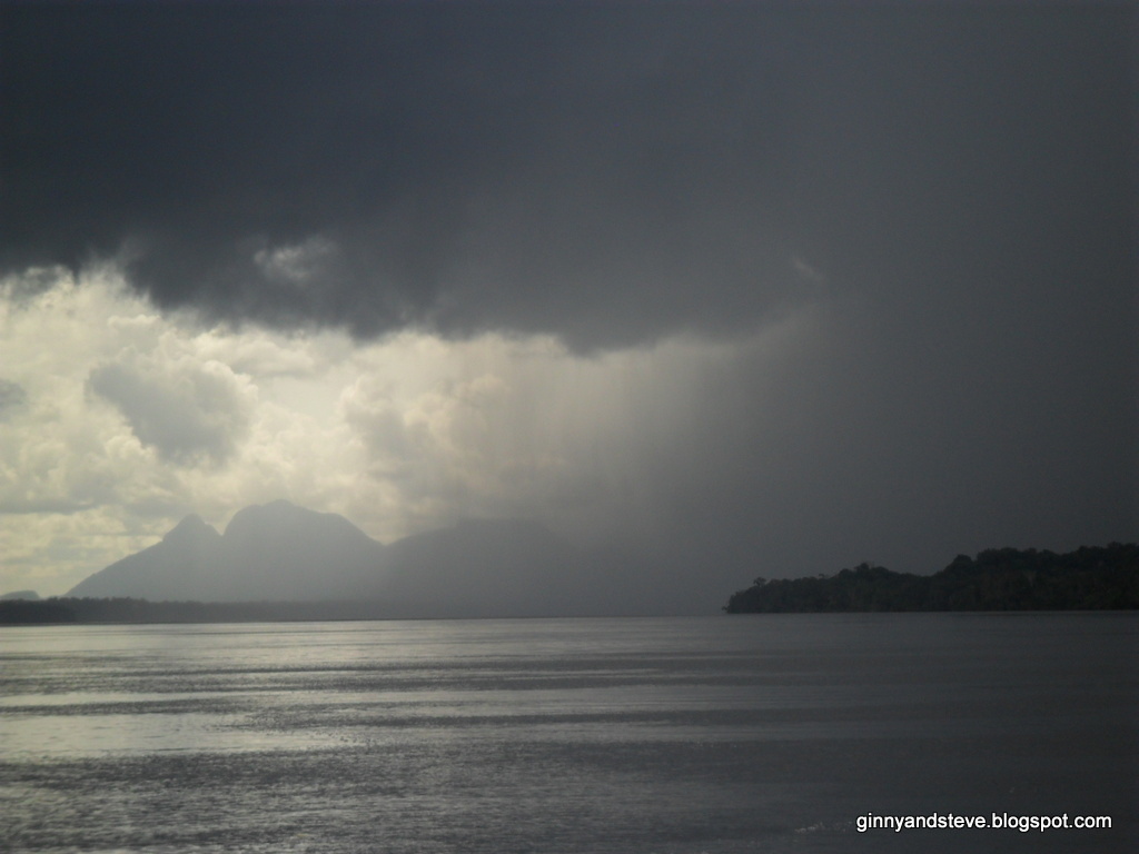
A diagonal crossing from one side to the other took two hours, during which the
daily rainstorm packed with lightning and black clouds passed over, blinding us
and kicking up waves.
After days of nothing but riverine swamp we began passing
tall red river banks. Then on March 6 we saw skyscrapers in the distance. The
river corridor had remained relatively untouched until its very end, where Manaus sits on the north
bank. The transition from wilderness to a metropolis of two million people was
abrupt and kind of painful.
In Novo Airão we had met a charming couple traveling from Trinidad. They had come up the Amazon in their famous motor-sailer,
the Passagemaker. We were the first
sailboat they had seen coming up the river and they were the first we saw
coming down it. A friend of theirs owned a big shipyard in Manaus and on his behalf they had invited us
to tie up there. We approached the city with this in mind, exploring the little
inlets along the way as is our custom. We were overwhelmed by everything. There
were motor yachts, jet skis, skyscrapers, barges; everywhere activity on a
large scale. We tied up beside Passagemaker
on a huge floating dock where barges were under repair. A new bridge loomed
nearby, separating us from the downtown.
We expect to be in Manaus
another couple of weeks. Having already tried your patience with this novel (in
which we could only scratch the surface of our experience), we will reserve an
in-depth description of Manaus
until our next email. Enjoy the many new photos to be found in:
http://www.picasaweb.com/ginnygoon/brasil